


GOOD NIGHT IRENE: I have been waiting nine days to say that. Now I can, as the NHC issued the last advisory at 10 p.m. tonight. Irene had weakened to a tropical storm before it made landfall near New York City around 9 a.m. EDT today. But as is often the case, the wind was not the biggest problem with a weak hurricane or strong tropical storm. And the flooding is not over by a long shot.
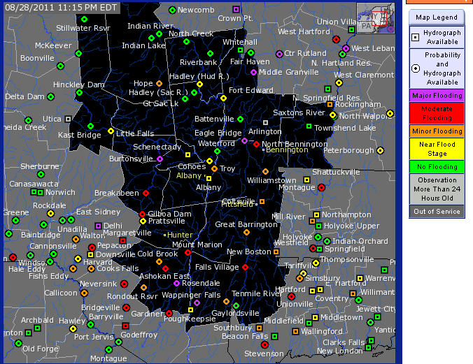
Irene delivered very heavy rainfall that is causing severe flooding across eastern New York and southern Vermont. Several rivers are reporting record stages. The rainfall across the mid-Atlantic fell on already saturated ground from heavy rains throughout the month. The soft ground made it easy for the tropical storm force winds to topple trees. This resulted in power failures for 15 million people at the height of the storm.
TROPICS NOT DONE BY A LONG SHOT: The ninth named storm of the 2011 Atlantic hurricane season was not even inland before the tenth storm was named. Tropical Storm Jose passed about 60 miles west of Bermuda around lunchtime today causing winds to gust to 45 mph. The system lost its deep convection Sunday afternoon and began to weaken. It will lose all tropical characteristics later today most likely.
NEXT UP, KATIA: We will likely see the eleventh named storm of the season sometime Monday or Tuesday near the Cape Verde Islands in the far eastern Atlantic. This system will make the long trek across the water between Africa and the islands. By Labor Day, it will be positioned just northeast of the northern Leeward Islands as it begins to turn northwestward thanks to a trough of low pressure over the western Atlantic, near the East Coast of the United States. It should recurve harmlessly away from the eastern U.S., although there could be some nervous moments before it does. There will be another system behind Katia. It will be named Lee.
ABOVE NORMAL SEASON: We have already notched ten named storms for the season. That is just below the average number of tropical storms in a season. But only one of them has been a hurricane. Now, Irene was a significant storm in terms of the accumulated cyclone energy it expended. Its final ACE will be 20, according to FSU’s Dr. Ryan Maue. This puts the ACE for the season at just under 37, which is higher than the typical 29 we would see by the time of the year.


