The tropical system in the Gulf of Mexico continues to circulate! A large area of showers and thunderstorms is north of the center, with a second area moving over northern FL. At least one tornado has been reported in Lake County tonight.

At the NOAA buoy about 110 miles south of Panama City Beach, sustained wind have been 23-27 knots over the past 3 hours, with gusts as high as 35 knots (40 mph), and 9 foot seas. Winds were 31 knots at an oil platform in the area. The TLH WSR-88D is picking up winds around 40 knots at 4,000 feet above the surface. We are close, but no call from NHC. A tropical storm must have sustained winds of 34 knots.
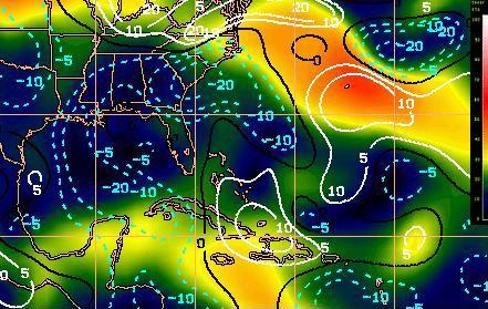
Water temps are in the mid 80s, and there is almost no shear. The chart below shows satellite-estimated shear and its tendency. In the eastern Gulf, the shear is very low and has decreased lately. So, most signs point toward development. The one thing holding back development now is the lack of convection right in close to the center, but convection is really going over a large area. We’ll see!