


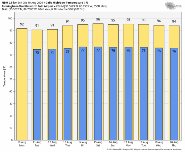
RADAR CHECK: Most of Alabama is rain-free this morning; we note just a few isolated showers near the Gulf Coast. The weather won’t change much through Wednesday… partly sunny days with random, scattered showers and thunderstorms mostly between noon and 9:00 p.m. Like recent days, heavier storms will produce gusty winds, lots of lightning, and very heavy rain. But, many communities won’t see a drop. So it goes on summer afternoons in Alabama.
A stronger upper ridge will creep into the region from the west by Thursday and Friday, which should mean higher heat levels and fewer showers and thunderstorms. Highs will be in the mid 90s on both days.
THE WEEKEND: The ridge holds, meaning highs remain in the mid 90s Saturday and Sunday with only isolated showers and storms during the afternoon and evening hours. A decent part of Alabama will simply be hot and dry.
Global models suggest the upper ridge will begin to retreat westward over the latter half of next week, which will open the door for slightly lower heat levels and a high coverage of afternoon storms in 10-15 days. See the video briefing for maps, graphics, and more details.
TROPICS: NHC is now monitoring three areas of interest across the Atlantic basin. The one with a highest chance of development is a small area of low pressure located a few hundred miles south of the Cabo Verde Islands in the far eastern Atlantic… it is producing disorganized showers and thunderstorms. As this system moves slowly westward, a tropical wave currently over west Africa is expected to merge with it in a couple of days. Environmental conditions are forecast to be more conducive for development by midweek, and a tropical depression could form during the latter half of this week while the system moves westward to west-northwestward across the central tropical Atlantic.
If a depression does form, it will likely turn north into the open Atlantic before reaching the Lesser Antilles and won’t be a threat to land. No tropical storm formation is expected near the contiguous U.S. for at least the next seven days.

ON THIS DATE IN 1856: A hurricane destroyed Isle Dernieres or Last Island, a pleasure resort south-southwest of New Orleans on this day. The highest points of the island were under five feet of water. The resort hotel was destroyed, along with the island’s gambling establishments. Over 200 people perished, and the island lost all its vegetation and split in half. Only one cow remained on the island after the catastrophe. The Last Island is now just a haven for pelicans and other seabirds.
ON THIS DATE IN 1976: Hurricane Belle moved up the East Coast and made its initial landfall early on August 10 on Long Island, New York, as a Category 1 hurricane. It then briefly crossed Long Island Sound and made a second landfall in Connecticut as a strong tropical storm.
ON THIS DATE IN 1980: After reaching Category 5 strength over the Gulf of Mexico, Hurricane Allen weakened and made its final landfall near Brownsville, Texas, on August 10 as a Category 3 hurricane.
Look for the next video briefing here by 4:00 this afternoon… enjoy the day!



