


SUMMER DAYS: An upper ridge will slowly strengthen across Alabama and the Deep South in coming days, meaning our weather will trend hotter and drier. Understand there is always the risk of a pop-up shower or storm on any summer afternoon here, but they will be fewer in number thanks to the ridge. It brings warmer air aloft, a more stable atmosphere, and sinking air motion that offsets the rising air from the summer heat.
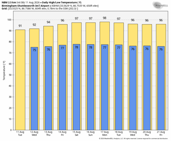
The chance of any one spot seeing a shower or storm today and tomorrow is 20-30 percent, then the probability drops to 10-20 percent Thursday through the weekend. Afternoon highs will be generally in the low 90s today and tomorrow, followed by mid 90s Thursday through Sunday. Some spots could reach the upper 90s this weekend. And, of course, with the higher dew points here in summer the heat index will exceed 100.
NEXT WEEK: Not much change. The ridge will be relatively strong, meaning sizzling summer days with highs in the 90s. Afternoon showers and storms will remain isolated… See the video briefing for maps, graphics, and more details.
TROPICS: While NHC continues to watch three areas of interest across the Atlantic basin, only one has a chance of becoming a tropical storm, an area of low pressure located about 500 miles southwest of the Cabo Verde Islands. Environmental conditions are forecast to gradually become more conducive for development during the next day or two, and a tropical depression will likely form during the latter half of this week while the system moves westward to west-northwestward across the central tropical Atlantic. Chance of development is 70 percent.
If this one develops global models show two possible scenarios… one is dissipation near the Leeward Islands due to very dry and and strong winds aloft. The other is a possible turn to the north over the open Atlantic.
No tropical storms or hurricanes are expected near the continuous U.S. for at least the next 7-10 days.

ON THIS DATE IN 1940: A Category 2 hurricane struck the Georgia and South Carolina coast. A 13-foot storm tide was measured along the South Carolina coast, while over 15 inches of rain fell across northern North Carolina. Significant flooding and landslides struck Georgia, North Carolina, Tennessee, and Virginia during the system’s slow trek as a weakening tropical storm, and then as an extratropical cyclone, through the Southeast. The landslides which struck North Carolina were considered a once in a century event.
ON THIS DATE IN 1999: An F2 tornado touched down in the metropolitan area of Salt Lake City. The tornado lasted ten minutes and killed one person, injured more than 80 people, and caused more than $170 million in damages. It was the most destructive tornado in Utah’s history and awakened the entire state’s population to the fact that the Beehive State does experience tornadoes.
Look for the next video briefing here by 4:00 this afternoon… enjoy the day!



