Temperatures at 3 pm are above 100 across much of north and central Alabama. BHM 103, ANB 102, TCL 100, HSV 100. Record already broken.
If anything, with little air movement and dry ground, we could approach 105 or 106 tomorrow. By the weekend, with the deep-layer ridge of high pressure breaking down a little and moisture increasing, more clouds and scattered afternoon storms will help keep temperatures a little lower. Still, we could be talking about 95-100, and with higher humidity, it will feel very hot. As James has been mentioning, models continue to show the upper-air pattern changing over the next 2 weeks, with better rain chances, and less heat!
It is worth pointing out that this is really the first significantly hot summer we’ve had in a long time. Since 1900, we average 14.7 days at 95+ per summer, and about 2 days at 100+ per summer. But, in 2001-2005, we only had 17 days total at 95, and none at or above 100. So, for the decade so far, this summer has brought things from below normal to near normal.
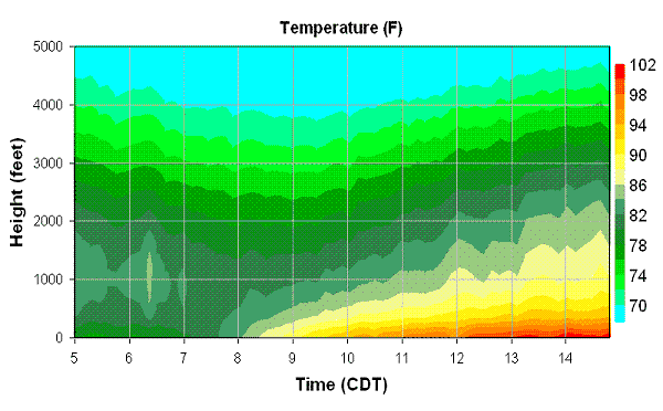
Finally, the Microwave Profiling Radiometer (MPR) is an instrument at UAH which takes a measurement of the temperature profile with height every minute. One can plot time-height sections of temperature to see how the atmosphere is changing. Below is today’s MPR temp vs. height and time (5 am through about 2:45 pm CDT). The first picture is up through 5,000 feet. Note how, while temperatures near the ground warm rapidly, temperatures at 4,000 feet barely change, warming from just below 70 in the morning to about 74 in the mid-afternoon.
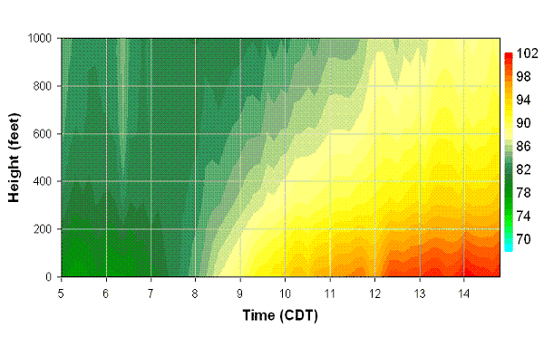
The second plot is zoomed in to the lowest 1,000 feet. Note how quickly the surface temperatures warm up in the morning, from 84 at 8 am to 93 at 10 am. In the afternoon, temps rise more slowly, as the depth of the hot air expands in the atmosphere, due to mixing.