


(Scroll down to read a fun post by JB on James’ anniversary and birthday!)
Wow. After a pleasantly cool May with temps in the 40s as late as May 17 and 7.98″ of rain for the month at the airport, summer has arrived quickly. It is 86 degrees as of 11 am at BHM, two degrees warmer than this time yesterday, so we should top out between 92 and 94 this afternoon.
I wouldn’t call 90 (yesterday) or even 93 (today) a heat wave. But, there are several factors working in this environment that should keep allowing temperatures to warm up another 1 or 2 degrees per day, and by this weekend, we may see upper 90s at a few locations.
First of all, we have subsidence, or sinking air in place over Alabama, under the big high pressure ridge. As air sinks (especially aloft), it is compressed and warms. That subsidence may start to weaken some this weekend as the high pressure ridge weakens and shifts east and south a little, but the warm air aloft is in place now.
The air warms generally from the ground up during the day. Sunlight doesn’t warm air directly much, but warms the ground, that then conducts the heat to the air. This time of year, since we are only about 2 weeks from the Summer solstice, we are having the longest days of the year and the days with the highest sun angles, meaning the most intense sunlight and the most sun energy coming in every day. Compare the energy (in Watts per square meter) by hour (the orange curve) between tomorrow (June 7) and January 1, shown below (based on equations from Klein 1948).
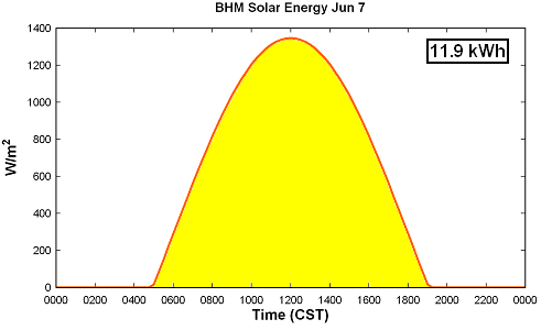
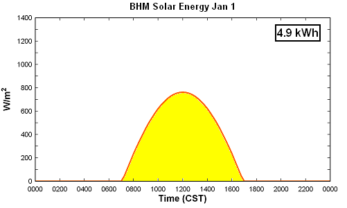
Notice how the day is not only much longer on June 7, but the sunlight is also more intense. The yellow area integrated under the W/m2 supplies the total energy, in kWh, that comes in from the sun on a square meter of ground (about a square yard). The ground is constantly radiating energy back into space, but not at the rate of even 10 kWh/m2. So, this time of year, unless we have an air mass change (cooler air moving in), rain, or a deepening of the boundary layer (the layer of air near the ground where the heat is spread out), the atmosphere will warm up a little every day.
Luckily, we’ve had plenty of rain so far this year, and one week without rain does not really start a new drought, does it? The ground has plenty of water, unlike last August, so some of the heat is used up evaporating that, and temperatures are held down a little by that. In this weather pattern, if we had not received all the nice rain in the Spring, we may be approaching 100. But, Sunday should be the warmest day, with highs between 95 and 98. With the humidity, though, heat indices will be over 100.



