


UPDATED AT 10:40 AM to reflect slow clearing of slush & ice in some areas. Shelby & Jefferson Counties in particular are very different from one side of the county to the other. Use caution when you drive, and ALDOT recommends that you only drive if necessary.
The heaviest of precipitation is exiting Alabama, and it with less-intense snow, sleet, and freezing rain, the highway situation will be changing throughout the morning and midday. The first rule of forecasting highway conditions is to remind you that we cannot see every situation with a computer screen. For example, in our parking lot here at ABC 33/40, we have patches ice and slush on light-colored concrete and in some shady sections of the asphalt parking lot. The very top of the ground may be less than 32 degrees, but a few inches down below, it is in the mid-30s around the Birmingham & Tuscaloosa areas (same in Clanton, Centreville, Demopolis, and all points in between). Since we did not have a heavy accumulation of frozen precipitation, the slightly warmer ground underneath will radiate some “heat” (just warm enough) to begin thawing some roads in Central and west-central Alabama. A general rule of thumb is that pavement that got full sun on Friday and Saturday will thaw first; shady spots are always the last to thaw.
Through midday, some improvement will be possible in the areas shaded in green below. Pink & white areas indicate where travel will be dangerous all day and all night.
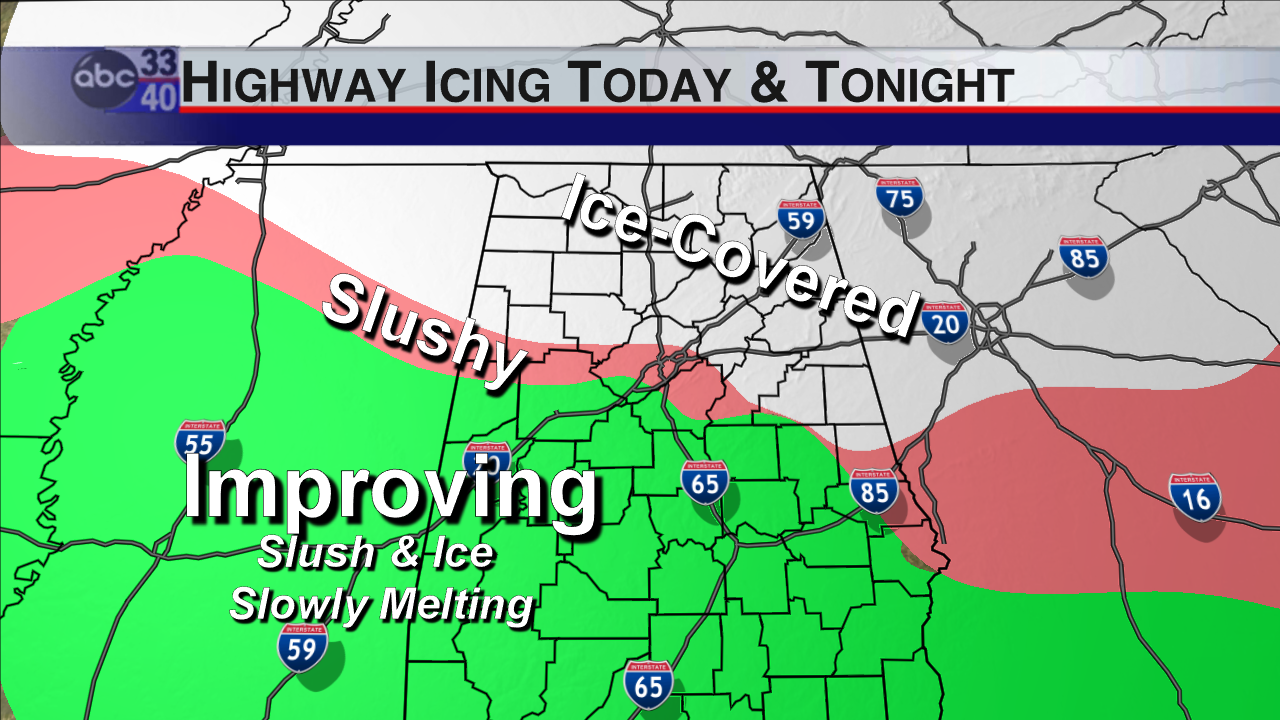
Expected Highway Conditions through Today and Tonight (updated 10:40 AM)
Where we show “improvement” does not mean it will be completely clear of ice! The best advice of all today is to stay home all across the northern 3/4 of the state and only travel in emergency situations. If we had some sun today, it would help a lot, but we won’t get it. Clouds will be thick, and the air temperature will rise to the mid-30s in the “improving” area; it will only get to around 30-32 degrees in the slushy/icy areas (especially where more than 4″ of snow fell overnight).
Some additional snow flurries, freezing rain, or freezing drizzle is possible on Tuesday with the advance of some bitterly cold arctic air. We should stay cloudy all day tomorrow, too. That means very little if any thaw for the “ice covered” areas. Temperatures will plunge into the 0s and 10s Wednesday, Thursday, and Friday mornings; daytime highs will only reach the 20s and 30s for mid and late week. This situation is one where Tennessee Valley schools (including some in Marion, Winston, Cullman, Blount, Etowah, Cherokee, and points north) could be closed all week. The weather folks don’t close schools, though! Listen for announcements from your local school districts.
I realize this opens the door for a lot of questions about other school systems. The bottom line is we will not likely know until tomorrow morning how bad the re-freeze was overnight. Let’s watch and see if we get any thawing and drying over the central part of the state before we speculate on Tuesday school open/close issues for Birmingham, Tuscaloosa, Shelby County, or the rest of central and west-central Alabama.



