


RADAR CHECK: Scattered showers and thunderstorms are over Alabama this afternoon, more numerous over the eastern and southern counties of the state. Like recent days, heavier storms are producing gusty winds and lots of lightning. Away from the scattered storms; temperatures are in the mid to upper 90s with a partly to mostly sunny sky.

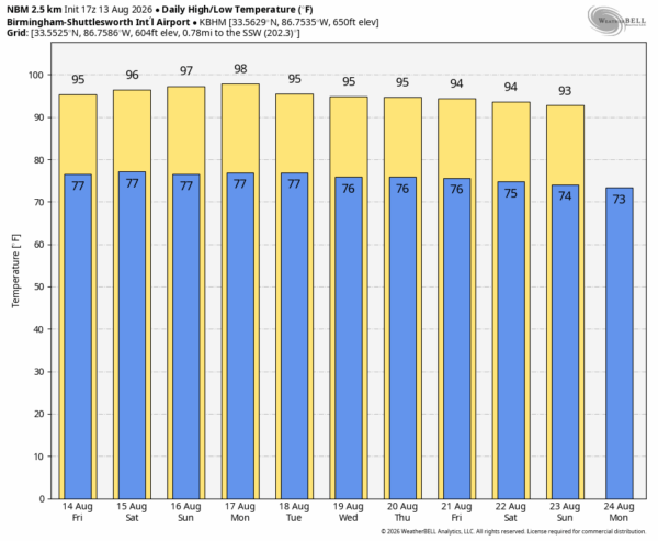
As you might expect in August, the weather will be hot for the next 7-10 days as an upper ridge parks across the Deep South. Most places will see a high in the mid 90s tomorrow, followed by upper 90s over the weekend. No doubt a few spots could touch the 100 degree mark, especially over the western half of the state.
And, every August afternoon we have a few random thunderstorms around Alabama, and that will be the case through Sunday. Most of the scattered storms will come from noon to midnight, and the higher coverage will be over the southern half of the state. Like recent days, heavier storms will produce strong wind gusts and lots of lightning. And remember, if you can hear thunder, you are close enough to be struck by lighting, even if it isn’t raining. “When thunder roars, go indoors”.
NEXT WEEK: No major changes. Hot summer weather with highs in the 90s and a few spotty showers and thunderstorms around during the afternoon and evening hours. See the video briefing for maps, graphics, and more details.
TROPICS: There are two tropical waves to watch in the Atlantic….
*Invest 92L is a tropical wave located about 1000 miles east of the Lesser Antilles. In addition, recent satellite-derived wind data indicate that the system does not have a closed circulation. This system is expected to move into a region of strong upper-level winds and dry air, and the development chances appear to be decreasing.
*Invest 94L is a tropical wave located several hundred miles southwest of the Cabo Verde Islands is producing disorganized showers and thunderstorms.
Environmental conditions are forecast to be generally conducive for gradual development, and a tropical depression could form late this week or this weekend while the wave moves westward or west-northwestward across the eastern and central tropical Atlantic. If anything develops, it will also encounter a hostile environment in 5 days or so and should weaken or dissipate by then.
No tropical storms or hurricanes are expected near the contiguous U.S. for at least the next 7-10 days.

ON THIS DATE IN 2004: Hurricane Charley made landfall on August 13, 2004, near Cayo Costa, Florida, around 3:45 p.m. EDT as a Category 4 hurricane with maximum sustained winds of about 150 mph. Charley then continued to produce severe damage as it made landfall on the peninsula in Punta Gorda. It continued to the north-northeast along the Peace River corridor, devastating Punta Gorda, Port Charlotte, Cleveland, Fort Ogden, Nocatee, Arcadia, Zolfo Springs, Sebring, Lake Placid, and Wauchula. Zolfo Springs was isolated for nearly two days as large trees, power poles, power lines, transformers, and debris filled the streets. Wauchula sustained gusts to 147 mph; buildings in the downtown areas caved onto Main Street.
Look for the next video briefing here by 6:00 a.m. tomorrow…



