


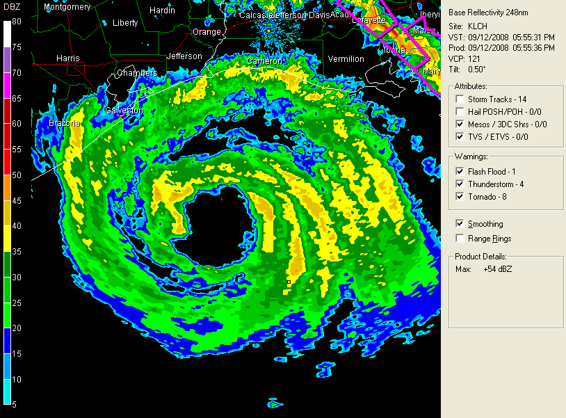
A sad situation tonight in Galveston. We have a large and powerful hurricane that has been downplayed by many people because it is only a category two on the Saffir Simpson Scale. Unfortunately, it has category four storm surge. There are many people still in Galveston…thousands.
The hurricane is trying to intensify. An inner eyewall trying to form. The recon team says there is no true eywall yet, but spiral banding very evident on west and southwest sides of center. Convection growing around the center. Central dense overcase more defined. Fortunately it is nearly on shore, so it doesn’t have much time to get stronger.
Center just under 100 miles southeast of Galveston.
Hurricane Research Division rates storm surge potential as 5.1 out of 6.
Storm surge potential…Texas…
Shoreline of Galveston Bay… 15 to 22 feet
Bolivar Peninsula… 17 to 20 feet
Galveston Island… … 14 to 17 feet
Gulf-facing coastline from Sargent to San Luis Pass… 8 to 14 feet
Expected Louisiana Surges:
Coastal Cameron Parish: 15 to 18 Feet.
Coastal Vermilion, Iberia and St. Mary Parishes: 12 to 15 Feet.
Coastal Terrebonne Parish: 9 to 12 Feet.
Coastal Southeast Louisiana, including New Orleans: 4 to 9 Feet.
A private levee broke this afternoon on the East Bank south of New Orleans near Scarsdale. Significant flooding occurred mainly in rural areas.
There was a nine foot surge in the Industrial Canal in New Orleans.
Other surge forecasts…
Mississippi coast: 4 to 8 Feet.
Alabama and Florida Panhandle: 3 to 6 Feet.
Galveston high tide 2 a.m. This adds two feet to the tide. Astronomical tides are falling now…but as that reverses durign the night, we will see rapid rises in the storm surge.
After the 1900 hurricane, the city of Galveston raised much of the city and built an impressive seawall. The seawall has protected Galveston through several hurricanes over the years. Tonight may be a different story. In fact, water is over much of the western end of the island. Water is in the historic downtown Strand area. The seawall may fail in spots and will certainly be overtopped.
Residents still remaining in Galveston have been told to shelter in place. There is a shelter of last resort at a high school, but it is getting impossible to travel. Earlier 40 percent of island residents had not evacuated. The police and public safety officials are hunkered down now.
I have only been to Galveston once, and i remember it well. It is sad to see water in downtown a la Katrina.
Winds picking up in Galveston. Power lines are down. No weather reports from Galveston since
The Gulf2 oil platform 35 southeast of Glaveston reported 63 mph sustained winds at 459 p.m.
Buoys
42035 NNE 50 mph gusting 65 mph…wave height 15.7 feet…pressure 29.10 and falling rapidly
Station 42361 – Shell Oil Platfomrm = 200 miles southeast of Galveston…wind instruments have failed. Center of the storm passed within 20 miles of the platform. Pegged at 106 mph this afternoon. At 6:45 a.m. this morning…a wind of 127 mph was observed.
TORNADOES
Several tornado warnings in Louisiana. A tornado watch is in effect for southern Mississippi and much of Louisiana.
Unrelated to Ike…tornado warnings are in effect for the Kansas City area.
BULLETIN – EAS ACTIVATION REQUESTED
TORNADO WARNING
NATIONAL WEATHER SERVICE KANSAS CITY/PLEASANT HILL MO
557 PM CDT FRI SEP 12 2008
THE NATIONAL WEATHER SERVICE IN PLEASANT HILL HAS ISSUED A
* TORNADO WARNING FOR…
WESTERN JACKSON COUNTY IN WEST CENTRAL MISSOURI
* UNTIL 630 PM CDT
* AT 553 PM CDT…NATIONAL WEATHER SERVICE DOPPLER RADAR WAS TRACKING
A CONFIRMED TORNADO AT 133RD AND STATE LINE ROAD…OR ABOUT 4
MILES SOUTHEAST OF OVERLAND PARK. DOPPLER RADAR SHOWED STRONG
ROTATION IN THIS AREA…MOVING NORTHEAST AT 25 MPH..
* THE TORNADO WILL BE NEAR…
INTERSTATE 470 BY 605 PM CDT.
RAYTOWN BY 620 PM CDT.
6 MILES WEST OF LAKE TAPAWINGO BY 630 PM CDT.
THE SAFEST PLACE TO BE DURING A TORNADO IS IN A BASEMENT. GET UNDER A
WORKBENCH OR OTHER PIECE OF STURDY FURNITURE. IF NO BASEMENT IS
AVAILABLE…SEEK SHELTER ON THE LOWEST FLOOR OF THE BUILDING IN AN
INTERIOR HALLWAY OR ROOM SUCH AS A CLOSET. USE BLANKETS OR PILLOWS TO
COVER YOUR BODY AND ALWAYS STAY AWAY FROM WINDOWS.
IF IN MOBILE HOMES OR VEHICLES…EVACUATE THEM AND GET INSIDE A
SUBSTANTIAL SHELTER. IF NO SHELTER IS AVAILABLE…LIE FLAT IN THE
NEAREST DITCH OR OTHER LOW SPOT AND COVER YOUR HEAD WITH YOUR HANDS.



