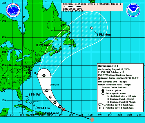
If one looks at the above map, showing Hurricane Bill’s track over the last 2 or 3 days, and then its forecast track over the next 5 days, it may make a few people along the east coast of the US (NYC, Boston) scared. But, a situation like this shows the importance of the years of research done on the atmosphere, the computer models that have been developed over decades, and the individuals who release weather balloons (I used to be one of them) twice a day, rain or shine, to feed data into the models.
As of about midnight, dropsondes (similar to weather balloons but transmit data up to plane) found winds of 134 knots (154 mph) in the eyewall, and peak flight level winds have been 140 knots (161 mph). So, to know exactly what the maximum sustained wind is at the ocean surface is difficult, but NHC estimates 115 knots with gusts to 140 knots. This is a Category 4 hurricane. It is producing 88 Terajoules of energy (that’s 88 x 10^12 Joules), or about 21 kilotons (kt) of TNT. This compares to the atomic bomb at Hiroshima, which was 15 kt. The liquid water in Bill weighs about 44 trillion pounds; moving at 20 mph this produces the momentum equal to 10,000 fully loaded coal barges moving at 100 mph, or a freight train running at 1,000 mph with 100,000 box cars in tow, or about 1,000 miles long.
Assuming the models are right (and they are in good agreement that the cold front coming out of the northern plains this weekend will turn Bill NE away from the US), Bill will move ashore in Nova Scotia, weakening but still a powerful hurricane. It will get very windy and rough along the shores from the Carolinas through Maryland, New Jersey, and New England this weekend. A buoy measured waves of 32 feet already with the storm, so heavy surf and gale force winds are likely in many Atlantic coastal areas by Saturday and Sunday.
How can a cold front turn something so heavy and powerful 90 degrees to the left? Well, hurricanes are constantly processing new weight (water) and power (wind), and minor adjustments in the surroundings can force some of the power just a little to the right. With 3,000 miles to go, only a 10 or 20 degree turn means 1,000 miles change in course.
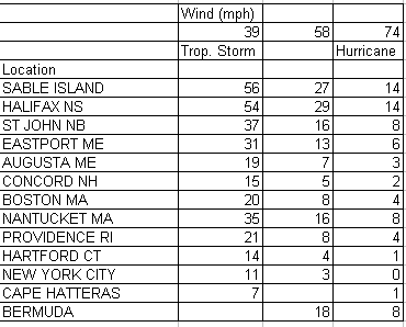
Still, with uncertainty and the large wind field, the National Hurricane Center provides the following charts for likelikhood of winds over tropical storm, 58 mph, and hurricane force at a point during the next 5 days: