


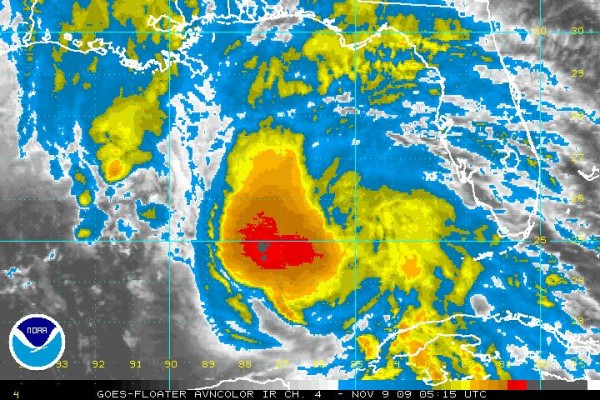
FAST FACTS ON IDA
12:00 AM CST Mon Nov 9
Location: 24.4°N 87.5°W or 435 miles south of Mobile
Max sustained: 105 mph
Moving: NNW at 15 mph
Min pressure: 987 mb
HIGHLIGHTS
…No change in warnings
…Ida looking a little more ragged on satellite…
…Drier air evident on southern side of storm now
…Ida moving into increasing wind shear…now under 30-35 knots of shear…will increase to over 40 knots later on Monday
…Sea surface temperatures no longer conducive to intensification and oceanic heat content is low ahead of the storm
…All of this points to a trend toward a transition to extratropical and weakening trend
…But Ida could bring hurricane force winds to the coast, likely between Gulf Shores and Fort Walton late Monday night/early Tuesday morning
…Tropical storm force winds will affect a wide area, as far north as Verbena in Central Alabama
…Hurricane warnings from Pascagoula MS to Indian Pass FL.
…Storm surge, beach erosion and high surf will be problems along the coast
…Rain fall will be very heavy near the coast and up into Central Alabama
J.B. will be along with updates starting early in the morning. Thanks for hanging with me all weekend as we have monitored this interesting storm.



