


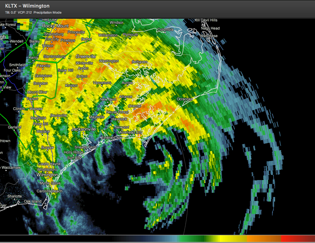
Irene has made her first U.S. landfall this morning just a few minutes ago near Cape Lookout North Carolina.
The hurricane is a lot more ragged on satellite pictures and the radar presentation is slightly less organized.
It is dumping heavy, soaking rains on eastern North Carolina this morning in places like Kinston and Jacksonville and Edenton and Manteo and New Bern and Beaufort and Swanquarter. Numerous flash flood watches and warnings are in effect.
Winds over Central North Carolina were out of the North in places like Charlotte, gusting to nearly tropical storm force during the pre-dawn hours. Winds gusted to hurricane force shortly before 4 a.m. CDT at Cape Hatteras.
Strong tropical storm force winds with gusts over hurricane force will be felt over eastern North Carolina and the Outer Banks this morning as Irene continues moving north northeast.
Those same winds will move up the coast with the storm, spreading into southeastern Virginia and up the Delmarva today. They will affect New Jersey and southern New York starting this afternoon through tonight, moving into New England during the pre-dawn hours.
Hurricane conditions are possible through the day in eastern North Carolina, along the coast of southeastern Virginia and the Delmarva through the evening, New Jersey through the pre-dawn until mid-morning Sunday and in New York City, especially along the coastal areas starting around sunrise and until about noon.
Long Island will bear the brunt, with the strongest winds arriving around sunrise and continuing for about 4-5 hours. Landfall should come about mid-morning on Central Long Island, east of New York City. Irene will bring hurricane conditions to parts of Connecticut, Rhode Island, Central Massachusetts and into a bit of Vermont and New Hampshire during the day on Sunday.
Boston will see strong tropical storm force winds and maybe a hurricane force gust. Irene should weaken below hurricane strength by 3 p.m. tomorrow and continue into Maine as a strong tropical storm.
OTHER THREATS: In addition to the strong winds, Irene will cause storm surge levels of 5-9 feet over eastern North Carolina, especially in the Pamlico and Albemarle Sounds. 4-8 foot storm surge is expected elsewhere along the Mid-Atlantic and New England coasts all the way to Cape Cod.
5-10 inches of rain will fall from eastern North Carolina across a waterlogged and saturated mid-Atlantic into New England. There will be some isolated 15-inch amounts. This will cause flooding and trees will be easily uprooted from the soft ground.
Beach erosion, dangerous surf and rip currents will be a big problem.
ALL IN ALL: Irene is a significant storm, and one not to be trifled with, but it is not Armageddon and residents of the mid-Atlantic and Northeast will take it nearly in stride.


