


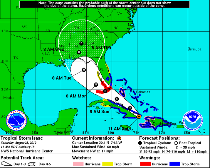
The latest advisory package is coming in on Isaac.
It is near the eastern tip of Cuba.
Winds 60 mph.
Moving NW a little faster at 17 mph.
Important development: forecast increased to 100 mph on Tuesday before landfall. That’s category two. There is a chance it will be even stronger.
Another important development: the storm is expected to really slow over southeastern and eastern Alabama Wednesday into Thursday. Some really high rain totals will result, especially near and east of the track.
Landfall forecast update: Skinny black line of the official track is lined up between Fort Walton and Panama City for a late Tuesday evening landfall, possibly near Destin.
Cone of uncertainty: everyone should be on alert along the entire coasts of Mississippi, Alabama and western Florida.
New warnings/watches issued up the west coast of Florida including Tampa and much of East Coast of Florida as well.
Here are the warnings:
A HURRICANE WARNING IS IN EFFECT FOR…
* THE FLORIDA KEYS INCLUDING THE DRY TORTUGAS
* THE WEST COAST OF FLORIDA FROM BONITA BEACH SOUTHWARD TO OCEAN
REEF
* FLORIDA BAY
A HURRICANE WATCH IS IN EFFECT FOR…
* HAITI
* THE FLORIDA EAST COAST FROM GOLDEN BEACH SOUTHWARD TO OCEAN REEF
* ANDROS ISLAND IN THE BAHAMAS
A TROPICAL STORM WARNING IS IN EFFECT FOR…
* DOMINICAN REPUBLIC
* HAITI
* CUBAN PROVINCES OF CIEGO DE AVILA…SANCTI SPIRITUS…VILLA
CLARA…CAMAGUEY…LAS TUNAS…GRANMA…HOLGUIN…SANTIAGO DE
CUBA…AND GUANTANAMO
* THE BAHAMAS
* TURKS AND CAICOS ISLANDS
* THE FLORIDA EAST COAST FROM SEBASTIAN INLET SOUTHWARD TO OCEAN
REEF
* LAKE OKEECHOBEE
A TROPICAL STORM WATCH IS IN EFFECT FOR…
* CUBAN PROVINCES OF MATANZAS AND CIENFUEGOS
* THE FLORIDA EAST COAST NORTH OF SEBASTIAN INLET TO FLAGLER BEACH
* THE FLORIDA WEST COAST NORTH OF BONITA BEACH TO TARPON SPRINGS



