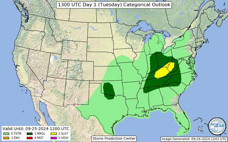
The Storm Prediction Center has placed parts of Northern Alabama under a marginal risk (level 1 out of 5) of severe thunderstorms today. This activity would form along a slow-moving cold front. Best window of opportunity is through the afternoon and evening. Not expecting anything widespread but a few storms could pulsate to severe limits and produce damaging wind gusts from 50-60mph, small hail, heavier rain and frequent lightning. Make sure you have a few ways of getting warnings just in case things get a little active this afternoon. We will keep you posted on the Alabama Weather Blog as well!
Published on: September 24, 2024 at 9:28 AM
Related Articles
October 21, 2026 at 1:14 PM
Sunny Pleasant Days, Clear Cool Nights Through The Weekend
**No afternoon video briefing today due to travel** TONS O’ SUN: Another sunny afternoon for Alabama with temperatures mostly in the 70s. Tonight will be clear with a low between 45 and 52 degrees. Not much change in the Alabama … Continue reading →
READ MORE
October 21, 2026 at 5:30 AM
Long Dry Spell To Continue Through Next Week
DRY: Not much change in the Alabama weather situation through the weekend. Sunny pleasant days, clear cool nights. Highs in the 77-82 degree range through Friday, then in the mid to upper 70s Saturday and Sunday. The long dry spell … Continue reading →
READ MORE