


It is certainly shaping up to be a very busy afternoon, evening, and overnight period for many area across the Southeast. We are watching a developing storm system over the Plains and Mississippi River Valley that is enhancing the atmospheric dynamics over the region today. Low pressure system will be sending a cold front into a warm, moist air mass in place today. Showers and storms are expected to develop to our west this afternoon and begin to race east this evening.
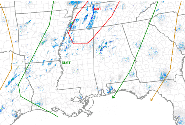
Early this morning, the SPC folks upgraded the risk category on their Day One Convective Outlook to moderate for areas from extreme northern Mississippi across much of western Tennessee and western Kentucky and the northwestern corner of Alabama. The reason is that there is an enhanced probability (45% or more of damaging winds in this area as well as a 10% or greater probability that there will be winds of 75 mph or greater). The probabilities are the chance that one or more of those events will occur within 25 miles of the points in the upgraded risk area. On the latest Day One Outlook just released from the SPC, not much has changed and it continues to show that much of Alabama remains in the standard slight risk for severe weather, outlined in green. Areas across northwestern portions of the state are outlined in red showing the moderate risk that has been issued.
It remains a very mild, windy day across Central Alabama and we should all make it into the 70s this afternoon. We even have a few showers moving north this morning and we will continue to see the chance of showers throughout the day. For the rest of today, these are the conditions we expect until we begin to see the thunderstorms approach.
All modes of severe weather are possible with this system, including a chance for some tornadoes, but this has been and continues to be a damaging wind event. Instability values are not overly impressive, but the wind fields above the surface are decent. These winds could easily be transferred down to the surface within any convection today and that is what is expected. There could be a few storms out ahead of the main line and those will warrant some extra watching, but the main threat will come during the squall line. Of course there is always a possibility of tornadoes within any bowing segments in the line, but we are continuing to emphasize the damaging straight-line wind threat.
TIMING: The models are being fairly consistent with this storm system. The main area of thunderstorms will develop to our west this afternoon. We will see the activity begin to race east and for locations in Alabama, the main threat window will be this evening and into the overnight hours. The main line of storms is expected to begin to enter the northwestern counties of the state around 630-730 PM this evening. In Central Alabama the high resolution NAM suggest the line of storms will be into Walker and Fayette counties approx 830-930 PM, and has storms arriving along the Interstate 59 corridor around 1130 PM. As the event unfolds later this afternoon and evening, we will have frequent updates and have all watch and warning details issued for our area.



