


…SEE JAMES’ POST BELOW FOR OFFICIAL NHC FORECAST…
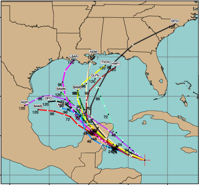
US Air Force aircraft found low enough pressures to consider this a triopical depression, with winds of 30 kt. It has become better organized, with the convection closer to the center of circulation. With less wind shear, it is likely that this system will become a tropical storm over the weekend, since it is so close already. Storms this early do not typically become major, and it will likely have to cross the Yucatan, but anything near the oil spill site is bad, especially since the counterclockwise flow around the tropical storm would push oil inland on the east side. If it stays to the south as some models indicate, there should be no major impacts on oil or the cleanup. But, if it turns north toward Louisiana/Mississippi/Alabama, cleanup could be delayed and more oil could come ashore along the Gulf Coast next week.
It is still impossible to tell where it is going right now. The stronger the heat ridge is over the SE US Sunday and Monday, the more likely it is the storm will stay farther south.



