


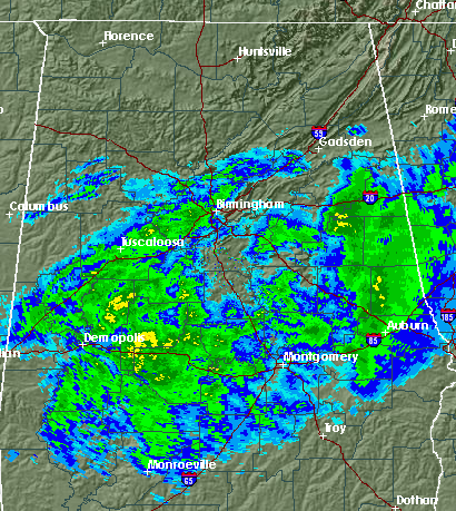
As you can see from the radar picture above, another area of snow is coming through the BHM metro area, but temperatures are still 34-37 degrees in most of central Alabama, and this snow doesn’t look heavy enough to take us all the way down to freezing. As we began to mention last night, the forecast got more complicated when warm, dry air came in above the surface. It seems that the dry air has evaporated some of the snow and reduced precipitation amounts to lower than we throught, while the warm air worked its way down to the ground just enough to prevent major accumulations in the BHM and TCL areas. Sometimes things don’t work out exactly as planned, and the small change that made a big difference was some warm air above the surface.
It’s coming down nicely here in Trussville right now, and at times it has covered grassy areas today in BHM. But, the main travel problems right now are actually north of a line from Jasper to Cullman to Gadsden to Centre. There have been reports of road closures due to icing in north Alabama, and we hear that I-565 is closed in Huntsville. Anyone north of the line mentioned should avoid travel if possible this afternoon and tonight.
Despite the unexpected warm, dry air that moved in last night, we thought the recent cold temperatures would allow for more accumulations in the BHM area than will likely occur now. It looks like 1/2″ is about the best we’ll get in central Alabama, except in isolated locations and on higher ridge tops, where 1″ could accumulate. This applies pretty much from BHM south to MGM. There may still be enough to make a snowman by late afternoon in places like BHM, Tuscaloosa, and Clanton, and a few roads, especially at higher elevations, may have slick spots as far south as BHM, especially once the sun starts to go down after 4 pm. The Arctic cold front is now in Tupelo, and will be here around sunset. At that time, with some wet road surfaces, ice may form as temperatures drop quickly into the 20s, so if you are still at work, try to go on home by 330 or 400 pm if possible.
The biggest story will remain the cold air, with temperatures over the weekend dropping to teens at night and only rising to near 30 in the daytime, wind chills near zero occasionally. Watch for icy spots on roads at least through Saturday, as ice that forms this afternoon and tonight will not melt easily with the cold temperatures, especially if it stays cloudy tomorrow.



