


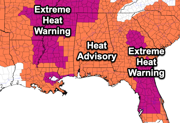
ANOTHER SCORCHER: All of Alabama’s 67 counties are under heat alerts again today, with most of the state in Heat Advisory, as heat index values across the state are over 105°, which is the danger range for much of the state. For southern sections of the state, the danger range is 108° are higher. Also, portions of the Tennessee Valley of state are included in an Extreme Heat Warning as heat index values over 110° are expected there this afternoon. Huntsville, Decatur, and The Shoals are included in this warning. We all know how to stay cool, but when you have such high heat levels the onset of heat illnesses, specifically heat exhaustion and heat stroke, will occur more quickly.
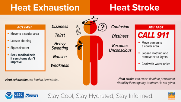
If you feel any of these symptoms, take action immediately.
Afternoon highs today are in the mid to upper 90s across the state, and though these are not near record values for this time of year, it is still very hot for late July. Rain chances today are in the 30-50% range, depending on where you are in the state. Though most locations will remain dry today, any storms that develop will be strong: BIG HEAT, BIG STORMS. An isolated severe storm with damaging wind gusts in the form of downburst will be possible. Of course all storms will produce tremendous amounts of lightning and torrential tropical downpours which can lead to areas of isolated flash flooding.
BIRMINGHAM ALMANAC: For July 29th, the average high for Birmingham is 91° and the average low is 73°. The record high is 105° set in 1952, while the record low is 60° set in 1911. We average 0.16” of precipitation on this date and the record value is 2.48” set in 1977.
USA BRIEF: Severe thunderstorms and excessive rainfall possible across portions of the Northern/Central Plains today. Excessive rainfall concerns in Southwest today followed by Southern/Central High Plains on Wednesday. Prolonged and expansive heatwave peaks in Southeast through mid-week.
REST OF WEEK: The ridge begins to weaken and shift west for the second half of the week, meaning heat levels begin to decrease while rain chances will increase. Highs will return to the low to mid 90s, which are right where they should be for the final days of July. Rain chances will be in the 50-60% range with the great coverage of rain and storms occurring the afternoon and evening hours.
WEEKEND WEATHER: The month of August looks to start off with well-below average temperatures with highs in the mid 80s Saturday, and potentially in the low 80s Sunday and Monday. The sky will be occasionally cloudy both days with scattered to numerous showers and thunderstorms around. No wash-out, but expect rain and storms from time to time both days, with higher coverage during the afternoon and evening hours.
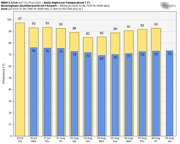
NEXT WEEK: The ridge begins to rebuild and shift east next week with highs back in the low and mid 90s by mid-week. Random, scattered showers ands storms are expected daily with the greatest coverage during the afternoon and evening hours.
IN THE TROPICS: The Atlantic Basin, including the Gulf and Caribbean are quiet for now with no tropical cyclone development expected the next seven days.

WORLD TEMPERATURE EXTREMES: Over the last 24 hours, the highest observation outside the U.S. was 125.8F at Basrah International Airport, Iraq. The lowest observation was -98.3F at Concordia, Antarctica.
CONTIGUOUS TEMPERATURE EXTREMES: Over the last 24 hours, the highest observation was 116F at Tecopa, CA. The lowest observation was 27F at Peter Sinks, UT.



