


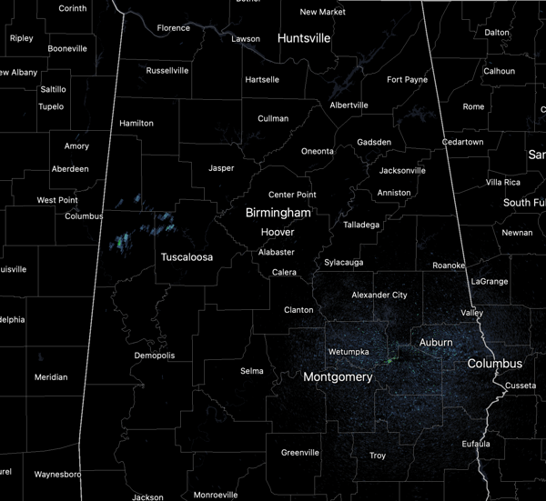
WELCOME TO AUGUST: Hot, humid, numerous showers and storms are the forecast for this first day of August across Alabama. Much of Central Alabama remains under a Heat Advisory as heat index values are in the 105°-108° range.
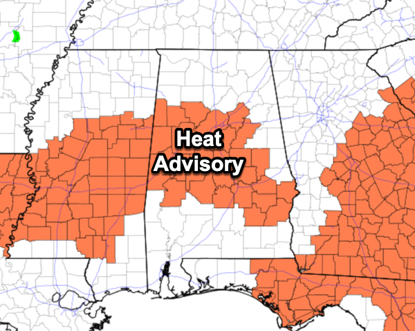
However, after today, we should be done with the heat alerts for a while. The radar will be very active through the afternoon and evening hours, and storms will be strong with gusty winds, frequent lightning, and torrential rainfall. Isolated flash flooding is possible and an isolated severe storm or two cannot be ruled out either. Rain chances are enhanced today due to a front dropping south through the state.
BIRMINGHAM ALMANAC: For August 1st, the average high for Birmingham is 91° and the average low is 72°. The record high is 101° set in 2010, while the record low is 59° set in 1955. We average 0.15” of precipitation on this date and the record value is 1.98” set in 1967.
JULY REVIEW: A quick review of July’s weather for Birmingham, the hottest temperature was 98° just a few days ago on July 29th. Our coolest afternoon high was 87° on July 3rd. Our lowest temperatures was 67° on the morning of July 4th. The city received 3.09” of rain, which is below the monthly average of 5.42”. The wettest day was July 8th when then city received 1.70”.
AUGUST CLIMATOLOGY SINCE 1900: August can be one of the hottest months for Alabama, and for Birmingham the hottest temperature on record is 105° set in 2007. The coolest temperature is 51° set in 1946. On August 1st, the average high and low are 91° and 72°. By the 31st of the month, the average high and low drop some to 89° and 69°. On average the city receives 4.22” of rain for the month, while the wetter August on record is 1901 when the city received 13.83”. The driest August is 1989 when the city received only 0.38” of rain.
ACROSS THE USA: Smoke from wildfires in Canada has prompted Air Quality Alerts over the Upper Great Lakes, Upper Mississippi Valley, and parts of the Middle Mississippi Valley today. There is a Slight Risk of excessive rainfall over parts of the Northern Plains, Southern High Plains, Southern Plains, and southern Mid-Atlantic, on today, and Central/Southern High Plains and the Southeast on Saturday. There is a Slight Risk of severe thunderstorms over parts of the Northern/Central High Plains today and over the Central High Plains on Saturday.
MUCH COOLER: Cooler air arrives behind the front this weekend, but also, to the east, a high over the Ohio Valley and low off the Atlantic coast, will cause a wedge front to move in from the north and east over the weekend. This will cause even cooler temperatures for Alabama over the weekend. Highs tomorrow will range from the upper 80s to low 90s, while Sunday’s highs will range from the upper 70s to mid 80s. Both days will feature more clouds than sunshine with occasional rain and storms. No wash-out, but expect rain and storms from time to time both days, with highest coverage during the afternoon and evening hours.
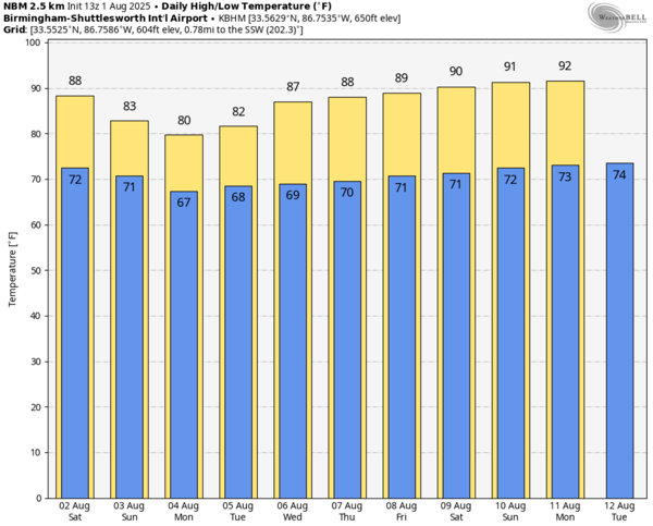
NEXT WEEK: Monday and Tuesday will continue to feature highs in the low 80s, but through the week, the ridge to our west begins to strengthen for the latter half of next week. Expect afternoon highs to return to the upper 80s Thursday and Friday, followed by low and mid 90s by next weekend. Each day will continue to feature random, scattered showers ands storms with the greatest coverage during the afternoon and evening hours.

IN THE TROPICS: The entire Atlantic Basin remains quiet with no tropical cyclone development expected the next seven days. We continue to see a lot of Saharan Dust over the Basin which for now, is limiting tropical cyclone development across the Tropical Atlantic.
WORLD TEMPERATURE EXTREMES: Over the last 24 hours, the highest observation outside the U.S. was 122.9F at Basrah International Airport, Iraq. The lowest observation was -98.5F at Concordia, Antarctica.
CONTIGUOUS TEMPERATURE EXTREMES: Over the last 24 hours, the highest observation was 114F at Tolleson, AZ. The lowest observation was 31F at Mackay, ID.



