


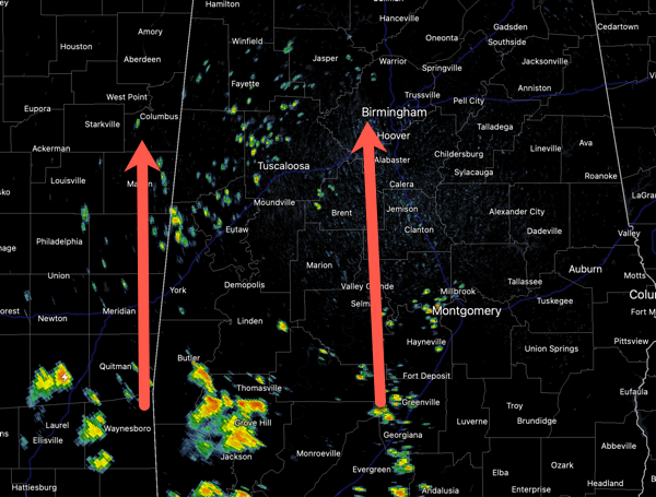
FINALLY FRIDAY: It is a routine late July day for Alabama with highs in the low 90s for much of the state. Scattered showers and storms will increase in coverage this afternoon and evening as daytime heating allows instability values to climb, providing fuel for the showers and storms. Once the sun sets, most of the rain and storms will begin to wind down and dissipate. With any storm this time of year, expect heavy rainfall and frequent, dangerous lightning.
BIRMINGHAM ALMANAC: For July 25th, the average high for Birmingham is 91° and the average low is 73°. The record high is 106° set in 1952, while the record low is 60° set in 2019. We average 0.18” of precipitation on this date and the record value is 1.49” set in 1922.
USA BRIEF: Dangerous, prolonged heat is ongoing in the Mid-South to Mid-Mississippi Valley and heat expands into the Northeast for a brief period today. Widely scattered instances of flash flooding due to heavy rains are forecast from northeast Kansas to much of Indiana. Scattered strong to severe thunderstorms are possible across parts of New England, northern Mid-Atlantic, and North Dakota.
BUILDING HEAT: Little change in our forecast the next seven days as we are going to see the hottest weather so far this year in Alabama. Over the weekend, rain chance fall below 20% range and highs will return to low and mid-90s tomorrow, followed by mid 90s Sunday. For next week, the upper-ridge will strengthen and we are going to see highs in the mid and upper 90s. I would not be surprised to see some low 100s on the maps several days next week.
Plan on more heat advisories being issued likely as early as Sunday, continuing for several days next week, as heat index values will climb into the danger range (greater than 105° for the northern two-thirds of the state, greater than 108° for the southern section of the state). I would not be surprised to see some Extreme Heat Warnings issued for portions of Alabama as well. These are issued when the heat index is likely to exceed 110°, and this is not entirely out of the question.
As far as rain chances for the first half of the week rain chances are expect to remain less than 20%, however, by the end of the week, the ridge will begin to weaken some and slide to the west. This will allow for rain chances to increase while afternoon highs are expected to decrease to the lower 90s.

IN THE TROPICS: A broad area of low pressure located about 100 miles south of the coast of southwestern Louisiana continues to produce disorganized showers and thunderstorms. This system is moving west-northwestward toward the Texas coast, and it has limited time to develop before it moves inland tonight. Regardless of formation, locally heavy rainfall is likely over portions of the northwestern Gulf coast during the next couple of days. Formation chance through 48 hours…low…10 percent. The rest of the Atlantic Basin is quiet for now.
WORLD TEMPERATURE EXTREMES: Over the last 24 hours, the highest observation outside the U.S. was 124.7F at Omidieh, Iran. The lowest observation was -99.2F at Vostok, Antarctica.
CONTIGUOUS TEMPERATURE EXTREMES: Over the last 24 hours, the highest observation was 110F at Tolleson, AZ. The lowest observation was 23F at Peter Sinks, UT.



