A few cumulus clouds are finally starting to show up across Alabama on this hot, autumn afternoon.
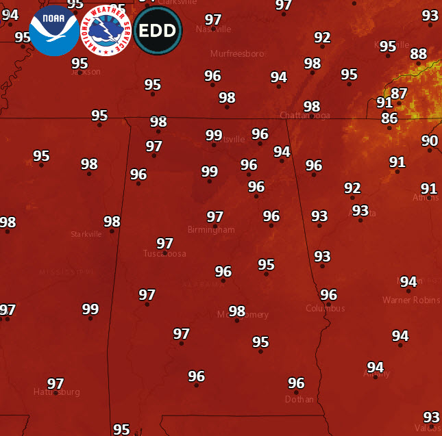
Temperatures are already in the 90s at nearly every reporting station in the state. By sunset, several stations will have daily record highs again, and several may establish new all-time record October highs. The forecasted high of 97F at the Birmingham Airport would smash the former hottest mark ever in October, 94F set on 10/1/1919, 10/5/1927, 10/6/1941, and 10/6/1954.
Highs this afternoon will look like this:
The hot and dry weather will continue for much of the week ahead.
A weak front will pass through the state Thursday night and Friday morning. This front will not have much to work within the way of moisture and the codl air advection behind will be weak, so we won’t notice very much change in our weather.
Saturday will still be hot and dry with highs in the lower 90s.
A second cold front will be approaching on Sunday. An easterly flow around high pressure will give us a slightly cooler, moist flow into the state. Expect a chance of showers and storms, along with highs in the 80s.
Monday will feature more of the same, with mostly cloudy skies and a chance of showers and storms. Highs will only be in the lower 80s. Still above normal for this time of year, but we will take what we can get.
This front will usher in a pattern change though, with highs dropping back into the 70s and 80s beginning Tuesday and beyond.