Daily Weather Briefing
Sunday, August 23, 2026
ALABAMA THIS MORNING
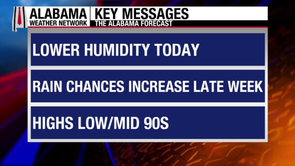
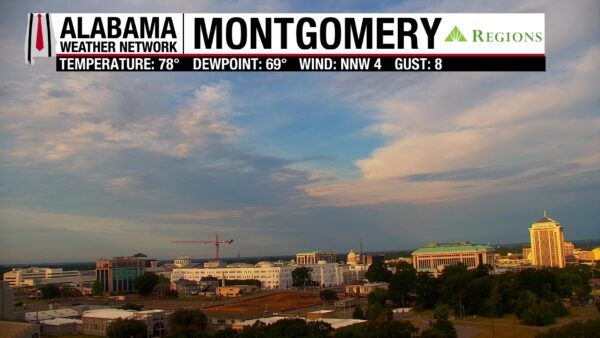
A band of clouds stretches across south-central Alabama along a stalled frontal boundary, while the rest of the state sees mostly clear skies. Temperatures are in the low 70s statewide, except for the southwest, where the mid to upper 70s, and even low 80s, can be found. Dewpoints range from the upper 60s to the lower 70s. The Regions Skycam in Montgomery shows a beautiful Sunday morning with pretty clouds in the sunrise light.
ALABAMA 7 DAY FORECAST
An upper-level ridge to the west and an upper-level trough to the north and east causes Alabama to sit under a northwest flow throughout the week. This will allow scattered to numerous afternoon showers and thunderstorms to develop every day this week. The rainier pattern will keep the state a little less hot than it has been the past couple of weeks, but it is still August in Alabama. South Alabama has a low-end severe weather threat today through Tuesday.
DRIEST DAY OF THE WEEK TODAY – Aug 23
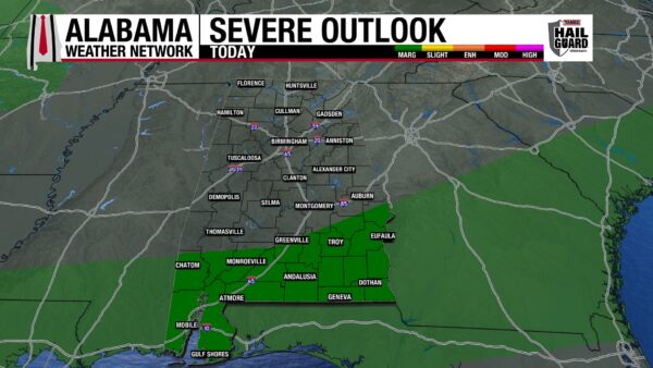
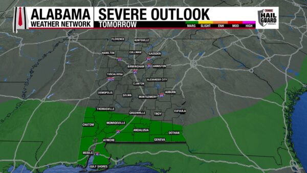
Today will be the driest day of the week as only a few isolated to scattered thunderstorms are expected to form over the southern half of the state today, while the northern half of the state should stay mostly dry. The southern third of the state will experience storms that will be Marginally (1/5) severe and could produce damaging winds, frequent lightning, and heavy rain. Highs will sit in the low 90s north, the low to mid 90s centrally, and the mid to upper 90s south.
NORTH ON THE DRIER SIDE, WETTER SOUTH TO START THE WEEK – Aug 24-25
We’ll see rain chances stay very low across the northern half of the state tomorrow and Tuesday as a stalled boundary over the southern third of the state keeps drier air over the region. Monday’s highs will range from the upper 80s to lower 90s across the upper half of Alabama. The low 90s will spread across the region on Tuesday.
The southern half of the state will see the greatest chances of afternoon thunderstorms Monday and Tuesday, with scattered to numerous storms possible both days. The low to mid 90s are expected for tomorrow’s highs, and the low 90s are anticipated for Tuesday. Storms that develop could become Marginally severe (1/5) and produce damaging winds, frequent lightning, and heavy downpours.
SCATTERED TO NUMEROUS THUNDERSTORMS STATEWIDE TO END THE WEEK – Aug 26-28
Wednesday through Friday will see higher rain chances in the northern half of the state while the southern half of the state keeps its high scattered to numerous rain chances. Storms that develop will be capable of gusty winds, frequent lightning, and heavy downpours at times, and although no severe outlooks are in place right now, that could change as we get closer to the end of the week. The good part about the rainier pattern is that highs will be limited, and we won’t be as hot as we have been recently. Highs on Wednesday will climb to the low 90s in the northern half of the state and the mid 90s in the southern half. Thursday will feel even better, with highs reaching the upper 80s in the northern half of Alabama and the low 90s in the southern half. The low 90s will stretch across the state on Friday.
RAIN CHANCES DECREASE SATURDAY – Aug 29
Saturday will see rain chances decrease across the state, but afternoon thunderstorms will still be possible. As they develop, they will be better described as isolated to scattered instead of scattered to numerous. Highs will be in the upper 80s to lower 90s in the north, the upper 80s to mid 90s (from east to west) in central Alabama, and the low to mid 90s in the south.
RAINFALL OUTLOOK
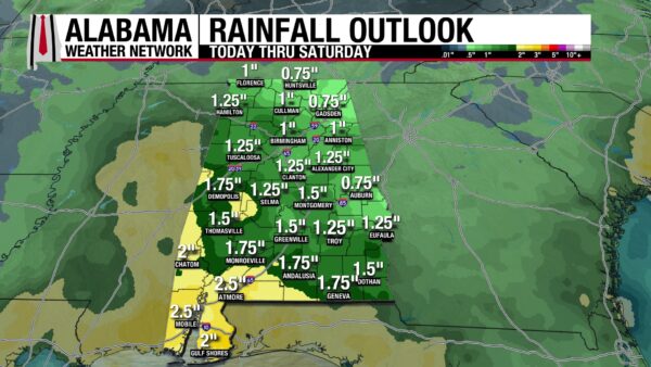
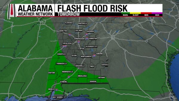
The average amount of rainfall Alabama is expected to receive over the next week reflects our rainier pattern well. Across most of the state, three-quarters of an inch to an inch and three-quarters of an inch of rain will fall. Southwest Alabama will see rainfall amounts up to 2 and a half inches. Locally higher amounts are possible statewide under thunderstorms. Tomorrow there is a Marginal Risk (1/4) for Flash Flooding in the southwest and south.
THE ATLANTIC
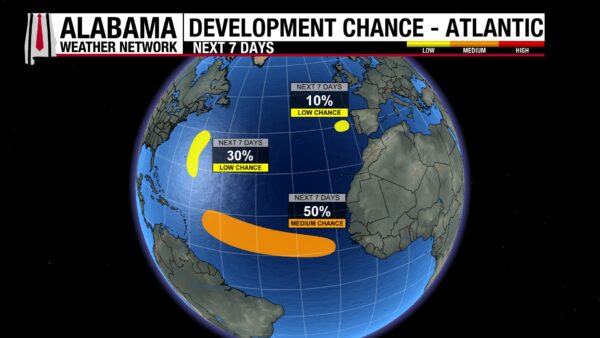
There are still three disturbances in the Atlantic Ocean the National Hurricane Center is watching for tropical development over the next week. In the Northeast Atlantic, the disturbance has a 10% chance of development. In the Central Subtropical Atlantic, disturbance AL95 has a 30% chance of development. The big story, however, is the tropical wave that will push off the coast of Africa Monday, and possibly form an area of low pressure in the Eastern Tropical Atlantic. Right now, there is a 50% chance this wave causes tropical system development.
THE PACIFIC
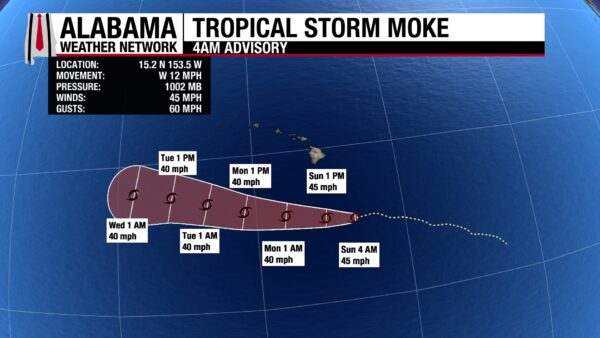
Tropical Storm Lala still sits in the middle of the Pacific Ocean. Tropical Storm Moke will pass south of Hawaii today as a tropical storm. It is expected to bring 5 to 15 inches of rain to the Big Island and 3-6 inches of rain to eastern Maui as it moves past the state. Areas of steep terrain and areas that were recently affected by Lala will be vulnerable to flash flooding and mudslides. It will also bring gusty winds, especially in high terrain areas.
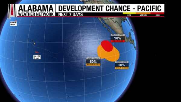
Three disturbances are also being watched for tropical development in the Pacific. The easternmost one has a 90% chance of development while the southern and eastern ones have a 50% chance of development.
GOOD BEACH DAY BEFORE A RAINIER WEEK
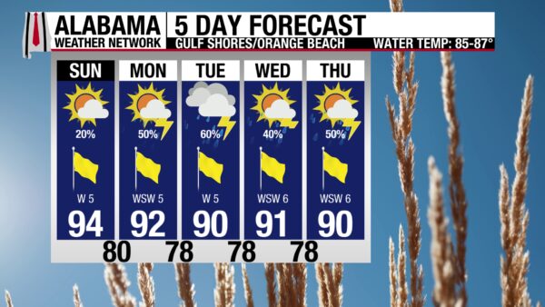
Beachgoers should enjoy the coast today, as today is the last day of rain chances at only 20%. Afternoon thunderstorm chances will sit between 40 and 60% this week, and the coast may be a tad more difficult to enjoy. Regardless, today’s high is in the mid 90s with mostly sunny skies and a Very High UV Index. Winds will blow from the west at around 5 mph, and the rip current risk is Low, with a surf height of 1 foot.
TODAY IN WEATHER HISTORY
August 23, 1964 – Cleo’s Rough Ride
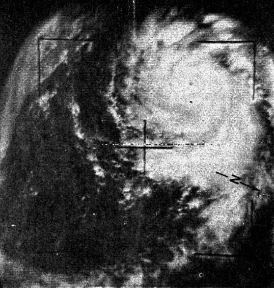
On August 23, 1964, Hurricane Cleo was near peak intensity in the northeastern Caribbean. The storm had strengthened rapidly after forming in the tropical Atlantic, and reconnaissance data found an intense hurricane with winds near 140 mph and a central pressure near 950 mb, or 28.05 inches. Near Puerto Rico, Cleo was a dangerous Category 4 hurricane.
That day, a Navy reconnaissance flight pushed into the storm to gather the information forecasters needed. In the early 1960s, hurricane aircraft were still one of the only ways to directly measure pressure, wind and structure inside tropical cyclones. Satellite meteorology was just beginning, radar coverage was limited, and a powerful storm over water still required crews willing to fly into it.
The eyewall penetration was brutal. The aircraft, a Navy Lockheed WC-121N Warning Star, suffered severe structural damage but returned safely. Aircraft records say the wingtips were ripped, much of the internal radar and electronic equipment was torn loose, and the fuselage was torque-twisted. The plane was later written off as beyond economical repair.
Cleo continued westward through the Caribbean, striking parts of the Lesser and Greater Antilles before crossing Haiti and Cuba. The storm later weakened to tropical-storm strength, then regained hurricane strength north of Cuba. On August 27, Cleo struck the Miami area, bringing significant damage from Key Biscayne northward along the Florida coast. It was Miami’s first hurricane strike in 14 years.
Cleo also marked a turning point in weather history. The TIROS satellite program was beginning to prove that storms could be watched from space, while aircraft still provided the direct measurements satellites could not. Together, those tools were changing hurricane forecasting. Cleo showed hurricane reconnaissance could be vital, dangerous, and revealing.
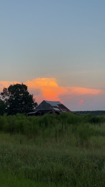
IMAGE OF THE DAY
Skywatcher Casey Waters captured an illuminated storm in Marianna, Florida, all the way from Ino, Alabama, yesterday evening!