


HIGHS HOLD IN THE 90s: Today represents the first day of meteorological fall, but we all know it doesn’t feel like fall around here in early September. A strong upper ridge will stay in place, and we are projecting afternoon highs in the 94-100 degree range for most of the state through the Labor Day weekend.
In this pattern there is always some risk of a brief afternoon shower or thunderstorm, but the upper ridge features warm air aloft which tends to keep showers few and far between. Odds of any one spot getting wet are around 20 percent across South Alabama, and 10-20 percent over the northern half of the state.
With the high dew points in place afternoon heat indices will exceed 100 degrees.
NEXT WEEK: The ridge holds; it looks like highs will be in the low to mid 90s for most of the week with only isolated afternoon showers/storms around. See the video briefing for maps, graphics, and more details.
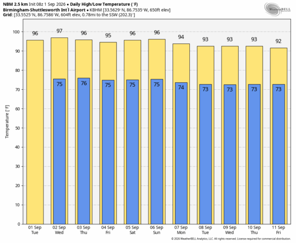
FOOTBALL WEATHER: We are projecting temperatures in the 96-99 degree range in Tuscaloosa Saturday by the fourth quarter of the Bama/ECU game at Bryant-Denny Stadium (kickoff at 11a CT). The heat index could be as high as 110. This will likely be one of the hottest Alabama home football games on record; the chance of a cooling shower during the game is small.
Jacksonville State, South Alabama, Troy, Alabama State, and Alabama A&M all have Saturday home games, but they are all evening games with temperatures falling through the 80s.
Auburn plays in Mercedes-Benz Stadium Saturday against Baylor (2:30p CT kickoff).. it will be a pleasant 72 degrees in the climate controlled dome.
UAB will take on Illinois in Champaign Thursday night (8p CT kickoff)… the sky will be clear with temperatures falling the low 80s at kickoff into the upper 70s by the second half.
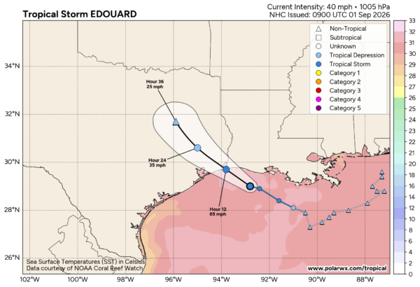
TROPICS: Tropical Storm Edouard, with winds of 40 mph, is about 90 miles southeast of Port Arthur Texas early this morning. The system is moving to the west/northwest at 8 mph, and landfall will come later today near the Texas/Louisiana border (Sabine Pass). Significant strengthening is forecast today and Edouard could approach hurricane strength before landfall; NHC is forecasting winds of 65 mph as it moves inland.
The rest of the Atlantic basin is very quiet and additional tropical storm formation is not expected for at least the next seven days.
ON THIS DATE IN 1859: The Carrington Event was the most intense geomagnetic storm in recorded history, peaking on 1–2 September 1859 during solar cycle 10. It created strong auroral displays that were reported globally and caused sparking and even fires in telegraph stations. Because society today relies heavily on interconnected electrical grids, satellites, GPS, and internet infrastructure, a modern repetition of the Carrington Event would be catastrophic.
Look for the next video briefing here by 3:00 this afternoon… enjoy the day!



