


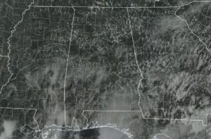
Good afternoon. As we are crossing over the midway point of the 3 o’clock hour this afternoon, we are seeing plenty of fair-weather cumulus clouds dotting the skies over the state of Alabama. As far as any precipitation, most of the activity is down over the southeastern portion of the state, while the rest of the activity is occurring in the western parts of the state around Geiger, Fayette, Vernon, and the northwestern parts of Tuscaloosa County. Temperatures are ranging from the lower 80s to right around 90 degrees at this point. The hot spot is Jasper at 90 degrees, while the cool spots are Greenville, Troy, and Eufaula, all at 83 degrees. Birmingham was at 85 degrees.
High temperatures are pretty close to what they are right now, but those lower 80s are probably due to rain-cooled air either at or close by to those reporting stations. The higher scattered shower and thunderstorm chances remain over the southeastern part of the state, with chances decreasing as you move north and west. Those chances will decrease as we head later into the day and in the evening hours. Most everyone will be dry this evening and tonight, with only a slight chance of an isolated shower or two south of the I-85 and US-80 corridors. Lows will eventually drop into the upper 60s to the mid 70s before the sun rises early on Sunday morning.
Everyone in the state will have a chance at showers and thunderstorms on your Sunday… Isolated afternoon storms will be possible over the northern half of the state, while chances increase as you move south. The greatest rain chances will be into South Alabama below the US-80 and I-85 corridors. Otherwise, skies will be partly to mostly sunny, while temperatures will be getting hot. We’re looking at highs in the upper 80s to the lower 90s once again… just another typical summer day in August.
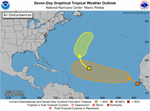
Now, out there in the tropics, we have a couple of areas that the National Hurricane Center are keeping an eye on.
1. Eastern Tropical Atlantic (AL97) is a broad area of low pressure off the west coast of Africa is producing disorganized showers and storms. Conditions seem favorable for gradual development, and there’s a MEDIUM (50%) chance a tropical depression could form by the middle to latter part of next week as it moves west-northwest at 15-20 mph. Locally heavy rain is possible in the Cabo Verde Islands Sunday and Monday. Stay tuned!
2. Central Atlantic (AL96) is a tropical wave in the central Atlantic has disorganized showers and thunderstorms. Development is looking unlikely for the next couple of days due to dry air, but there’s a LOW (20%) chance of gradual development by the middle of next week as it moves northward.
Keep an eye on the tropics, everyone! We’ll share updates as needed



