


Daily Weather Briefing
Saturday, April 18, 2026
ALABAMA THIS MORNING
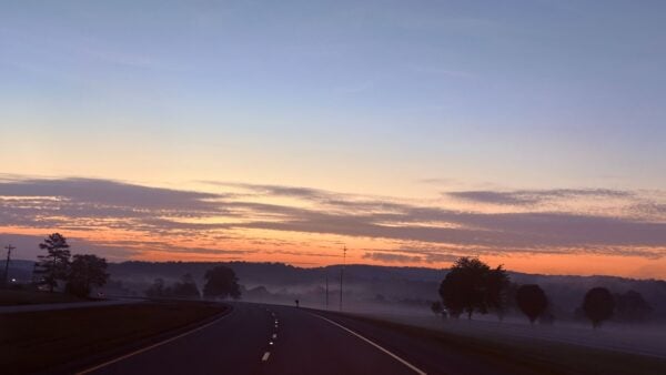
Clouds stretch across most of Alabama this morning, with just a few locations in the south staying clear. Current wind gusts are in the 10-15 mph range for north, west, and in some of south Alabama, while the rest of the state sees gusts below 10 mph. Temperature readings come in at the low to upper 60s in the north and central areas, while the less cloudy south sees the upper 50s. Gulf Shores has already hit 70 degrees. Skywatcher Daniel Harbin sent in the most beautiful picture of the sunrise in Woodville along Hwy 72.
ALABAMA 7 DAY FORECAST
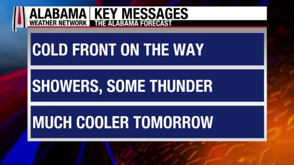
Today will develop into another warm day, while cloud cover increases ahead of a cold front. It will enter the state this afternoon, bringing showers and some thunderstorms throughout the night. The front and showers will arrive in south Alabama by the early morning hours and will continue through early Sunday afternoon at the latest. No storms are expected to be severe. Another high-pressure, upper-level ridging system will settle in place for next week, until another cold front is expected to bring some more rain next Friday.
CLOUDY SATURDAY
In response to increased moisture advection before the front, skies will be mostly cloudy statewide today. Winds will gust from 10-20 mph across the state as well. Despite the clouds and winds, highs will still manage to reach the low to mid 80s in the north and the mid 80s centrally and in the south. Some light showers ahead of the front will fall in north and north-central Alabama early this afternoon.
COLD FRONT PASSAGE TONIGHT
The front will enter the state late this afternoon, packing its strongest punch in this original entrance. Northwest Alabama will receive the most rain, with the area expecting 0.5”-0.75”. The highest potential for strong thunderstorm development exists in this region as well, with small hail and gusty winds possible as the storms will be able to feed off the daytime warmth.
The front will continue southeastward throughout the night, and thunderstorm potential dwindles quickly as the sun goes down, but it does not reach zero. Rainfall amounts decrease quickly as well, staying in the 0.1-0.01” range in central Alabama.
By early Sunday morning, showers will have entered southwest Alabama. The south as a whole is expecting to see the least amount of rainfall with this system, although it is the area that needs it most. Showers will be light, and thunderstorms will not be strong.
Lows will start to be very cool, as north Alabama drops to the mid 40s, and central and south Alabama hit the upper 40s and lower 50s. The coast may stay in the mid 50s, and southeast Alabama will hold onto some 60-degree readings.
DRYING QUICKLY SUNDAY
Most of the state will already be dry by sunrise Sunday morning, but south Alabama, mostly the southeast, will see some lingering showers through tomorrow afternoon at the latest. A cooler, drier air mass will be moving into the state behind the front. Fire weather concerns return, as relative humidities will be low, and winds will be gusting into the 20s. Whether a Red Flag Warning is issued depends on how much rain the state actually receives, as well as how quickly the rain moves out of the south. Regardless, caution should be exercised with an open flame. Highs will be much cooler than what we’ve seen recently, topping out only at the upper 60s north and the eastern portion of central Alabama, and the lower 70s for the western portion of central Alabama and the south.
RETURN TO WARM NEXT WEEK
This respite from the warm weather will be short-lived, as the dry airmass will allow for quick heating each day next week. The presence of a strong surface high-pressure system will also help temperatures climb. Fire will be a concern throughout most of next week as well.
Monday, highs will be in the low to mid 70s north, and upper 70s across the rest of the state. Winds will be gusty at times, staying around 20-25 mph for much of the state.
Low 80-degree readings will spread over the state Tuesday. Winds will be much calmer, but conditions will still be quite dry.
MID 80s WEDNESDAY AND THURSDAY
Highs will reach the mid 80s statewide on both Wednesday and Thursday as we continue to keep an eye on fire potential, especially in severe and extreme drought areas.
RAIN FRIDAY?
Another shift in the weather pattern is expected Friday as a cold front will push through Alabama. As of now, it does not look to be a washout, as rain chances across the state are at 20%. Highs will be in the upper 70s for the most northern part of the state, then the low to mid 80s spanning Alabama.
WORSENED DROUGHT
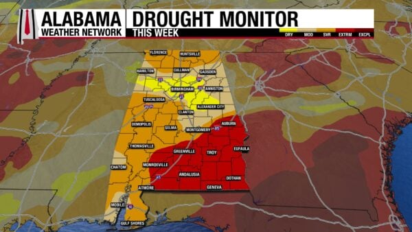
The past week has been very dry and has caused drought conditions to worsen. Last week, 11.49% of the state was drought-free; now, none of the state remains that way. Severe Drought conditions have increased almost triple in size from last week, now sitting at 41.58% of the state under these conditions. Extreme Drought conditions were exacerbated as well, moving from 17.96% to 24.57%. We will only see these conditions worsen as we head into the bone-dry week next week.
ENJOY THE RAYS TODAY
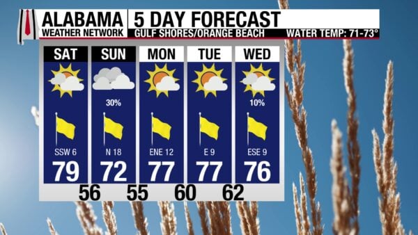
A change in the pattern is on the way, so get outside and enjoy the summer-like weather while you can today! A high in the upper 70s, partly sunny skies, an Extreme UV Index, and southwest winds at 5 to 10 mph are very summer-feeling conditions. Additionally, the rip current risk is low, and the surf height is around one foot, so if you need to cool off from the sun’s rays, the mid-70-degree water will cool you off in no time- and it will be calm! Showers tonight lead to a cool off tomorrow, and the next few days will be cool.

TODAY IN WEATHER HISTORY
April 18, 1970 – The Sherwood Shores Tornado
The April 17–18, 1970, tornado outbreak in the Texas Panhandle occurred as a strong upper-level low moved onshore in California and a broad upper trough set up across the southern Plains, producing a widespread severe weather event that generated multiple supercell thunderstorms and at least four F3 to F4 tornadoes between Amarillo and Lubbock, Texas. After an active evening of warnings issued by the U.S. Weather Bureau office in Lubbock, an all clear was sounded around midnight, and conditions briefly appeared to stabilize. During the predawn hours, however, additional tornadic storms developed and intensified, including a powerful F4 tornado that moved through the Sherwood Shores resort near Greenbelt Reservoir, about four miles south of Clarendon. The Sherwood Shores tornado tracked for approximately 9 miles with a maximum width of about 1,000 yards and lasted around 30 minutes, striking a mobile home park that contained about 1,000 trailers where roughly 150 people were present that night. As the tornado moved through the resort, it destroyed 172 trailers and killed 13 people, many of whom had returned to their homes after the earlier all-clear had been issued. Across the broader outbreak, multiple tornadoes occurred across the Texas Panhandle region, contributing to a total of about 23 fatalities, with additional deaths in nearby communities including Whiteface, Cotton Center, and Plainview.

IMAGE OF THE DAY
Skywatcher Sandra Kirkwood captured a screen-saver-esque photo of fluffy cumulus clouds over a field in Meridianville yesterday!



