


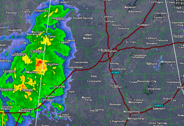
The rain shield we have been watching over Mississippi throughout the morning has made it into our western counties this afternoon. Showers with embedded thunderstorms are causing moderate to heavy rain to fall west of Highway 43, along and up and down the state line with Mississippi. This rain will continue to expand eastward throughout the afternoon and should be into the Birmingham area in the next couple of hours.
The rain has been very heavy over Mississippi this morning as there were several flash flood warnings issued. The intensity of the rain has lessened some as there is some drier air in the mid-levels of the atmosphere over the state. All of Alabama will see a soaking rain over the next 18-24 hours as an upper-level trough moves across the Southeast. We will be watching for a threat of isolated flash flooding and even now, parts of Lamar County are under an Areal Flood Advisory. The text of that advisory is below the radar image.
THE NATIONAL WEATHER SERVICE IN BIRMINGHAM HAS ISSUED AN
* URBAN AND SMALL STREAM FLOOD ADVISORY FOR…
CENTRAL LAMAR COUNTY IN WEST CENTRAL ALABAMA…
THIS INCLUDES THE CITY OF VERNON…
* UNTIL 315 PM CDT
* AT 115 PM CDT HEAVY RAINFALL OF AROUND ONE INCH PER HOUR RATE IS
FALLING OVER CENTRAL LAMAR COUNTY AND COULD CONTINUE OVER THE NEXT
HOUR. THIS WILL CAUSE URBAN FLOODING PROBLEMS IN DOWNTOWN VERNON
NEAR HIGHWAYS 17 AND 18 IN THE LOW LYING AND POOR DRAINAGE AREAS.
USE CAUTION WHEN TRAVELING THIS AFTERNOON.
PRECAUTIONARY/PREPAREDNESS ACTIONS…
EXCESSIVE RUNOFF FROM HEAVY RAINFALL WILL CAUSE ELEVATED LEVELS ON
SMALL CREEKS AND STREAMS…AND PONDING OF WATER IN URBAN AREAS…
HIGHWAYS…STREETS AND UNDERPASSES AS WELL AS OTHER POOR DRAINAGE
AREAS AND LOW LYING SPOTS.



