Daily Weather Briefing
Saturday, October 3, 2026
ALABAMA THIS MORNING
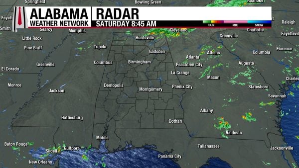
A few showers spread across the northernmost portion of Alabama this morning, while the rest of the state is dry for now. Temperatures are in the mid to upper 70s, and dewpoints aren’t too far behind in the low to mid 70s. This muggy morning is accompanied by partly to mostly cloudy skies.
ALABAMA 7 DAY FORECAST
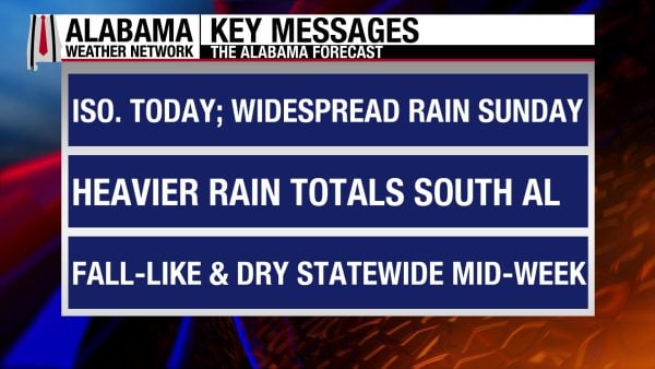
Southerly flow from the Gulf increases moisture across the state today and tomorrow as a stalled frontal boundary sits over the northern half of the state today. These factors will work together to bring isolated to scattered showers to most of the state and scattered to widespread showers to the south today. Tomorrow, rain chances increase statewide as the front finally begins to move southward. Cooler, drier air filters into the state behind the front next week, although it will linger in the south for a tad longer.
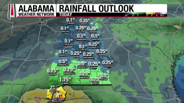
ISOLATED TO SCATTERED SHOWERS TODAY – Oct 3
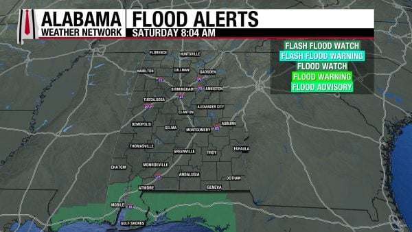
Luckily for football fans and those with outdoor activities, today will not be a washout. Rather, showers and thunderstorms will be isolated to scattered across the northern two-thirds of Alabama. Southern, and especially coastal Alabama, have the greater rain chance today, with scattered to widespread showers and thunderstorms forecast. Any thunderstorms that do form will only bring a lightning threat, as heavy rainfall remains the biggest concern this weekend. Rainfall amounts today will not be cause for too much concern for most of the state as up to a quarter of an inch is expected over the northern two-thirds of Alabama (although locally higher amounts are possible). South and coastal Alabama will receive more: from half an inch to an inch and three-quarters in the south and 2-4 inches on the coast. These large numbers on the coast are of more concern, so the region is under a Flood Watch through Monday at 12 a.m. The day will be cloudy, and highs will be limited to the mid to upper 80s statewide.
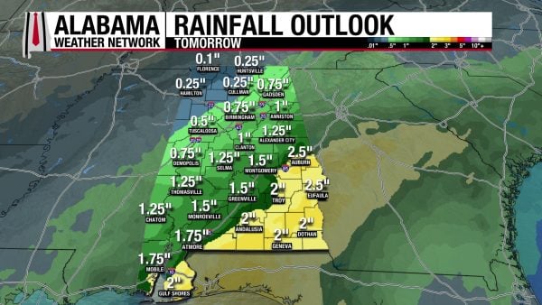
MORE WIDESPREAD RAIN TOMORROW – Oct 4
As that front dislodges from its stalled position tomorrow, rain will be more widespread. The area with the chance for the least amount of rain is northwest Alabama, as the front has already moved through that region. Otherwise, the northern half of the state has a 70% chance of showers and thunderstorms, and the southern half has a 90% chance. Rain is possible throughout the entire day, which is cause for concern in terms of rain totals. As mentioned, northwest Alabama will not see much rain, only about a quarter of an inch. Most of the rest of the state, however, could see half an inch to an inch and three-quarters, with locally higher amounts possible. Coastal and southeast Alabama will see even more, as 2-2.5 inches is forecast in these regions. Flash flooding is possible, so exercise caution while driving. More on the flash flood threat in the Rainfall Outlook section below. Highs will only reach the upper 70s to low 80s statewide.
STARTING TO DRY UP NEXT WEEK – Oct 5-6
Rain chances diminish completely in the northern half of the state by Monday, while a 50% chance of rain sticks around in the southern half of the state as the front struggles to move fully out of Alabama. Any showers that do impact the region will be scattered and be less of a rain threat, although the ground will be saturated and not a lot of rain will be necessary to cause isolated flash flooding. Although the front brings cooler and drier air, it is not going to be that burst of very cold air, but rather a nice decrease from the low 90s we were experiencing last week. Highs on Monday will climb to the low 80s across Alabama.
On Tuesday, rain chances fall to 30% in the southern half of the state, and highs will range from the upper 70s in the southeast to the low 80s over the rest of Alabama.
LITTLE TO NO RAIN TO END THE WEEK – Oct 7-9
Rain chances will stay between 10 and 20% in the southern half of the state from Wednesday onward, and the northern half of the state will still be completely dry.
Wednesday will see the upper 70s spread across most of the state, while the low 80s stick around in north and west-central Alabama. Lows on Wednesday morning will be in the pleasant mid 50s.
Thursday morning will also start off in the mid 50s then increase to the upper 70s to lower 80s across Alabama.
The mid 50 mornings will persist into Friday, then the low 80s will dominate Alabama by the afternoon.
RAINFALL OUTLOOK
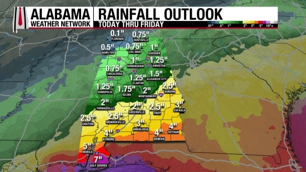
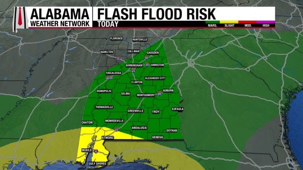
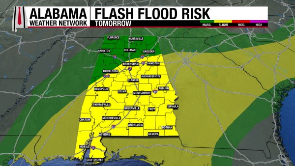
Rainfall amounts over the next week range from a quarter of an inch in the northwest to three-quarters to 2 inches over north and most of central Alabama, 2.5 to 4 inches in eastern south-central and south Alabama, and 5 to 7 inches in coastal Alabama. Most of this rain will fall over the next two days, raising flash flooding concerns. As mentioned above, coastal Alabama is under a Flood Watch this weekend, but the Weather Prediction Center has also placed flash flood outlooks in Alabama. Today, there is a Marginal Risk (1/4) for flash flooding across most of Alabama, excluding the northwest. Southwest and coastal Alabama are also excluded, but that is because they are under a Slight Risk for flash flooding today. Urban, low-lying, and poorly drained areas have the potential for flash flooding as these storms have plenty of rain to dump out. The Marginal Risk will be contained to the north and western north-central Alabama tomorrow, while the rest of Alabama is engulfed in a Slight Risk. If a roadway or walkway is flooded, remember: Turn Around, Don’t Drown! Do not drive or walk through floodwaters.
STILL WORSENING DROUGHT
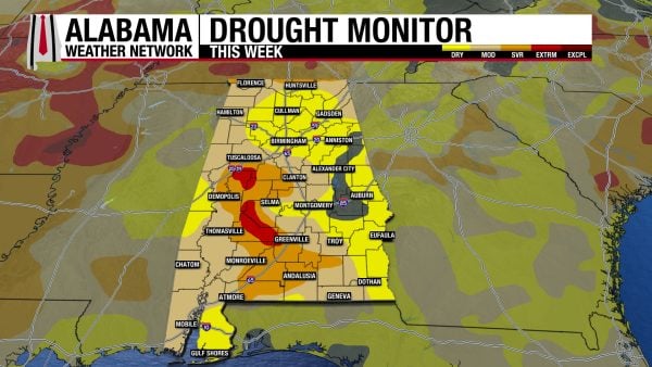
We enter October dry: only 5% of the state is experiencing no drought conditions right now. 39.18% of Alabama is experiencing Moderate Drought (D1) conditions, up around 4% from last week. The amount of Alabama experiencing Severe Drought (D2) conditions this week is 14.93%, also up around 4% from last week. And now, the drought in the southwest has worsened ot Extreme Drought (D3), which takes up 2.46% of Alabama. Although we are expecting some rain this weekend, dry conditions look to return next week, so relief from the drought will be limited.
FOOTBALL FORECAST
BAMA VS. MSU
Alabama travels to Starkville to take on Mississippi State at 11 a.m. CDT. A shower is possible, but most of the game should be rain-free. Temperatures will hover in the 80s with a mostly cloudy sky.
AUBURN VS. KNOXVILLE
Auburn is also on the road; they play Tennessee in Knoxville at 2:30 p.m. CDT. Again, a shower is possible, but a mostly dry game should be the case. Temperatures will be around 80 degrees.
UAB VS. SAMFORD
UAB will host Samford at Protective Stadium in Birmingham at 2:30 p.m. It will be a mostly cloudy afternoon with a chance of a shower or two. Temperatures will be in the mid to upper 80s at kickoff.
MORE HOME GAMES
Tuskegee, South Alabama, and West Alabama all have home games. A few showers are possible during each game.
THE ATLANTIC
Although there was a very small chance the remnants of Fay were once again revived, that chance has completely fizzled out, and the Atlantic basin is quiet again.
THE PACIFIC
Hurricane Rachel and Nolo are still active in the Pacific. Hurricane Rachel sits off the coast of Mexico with sustained winds of 90 mph and a central pressure of 969 mb, which makes it a Category 1 storm. It is forecast to move west-northwest in the coming days and finally weaken to tropical storm status on Thursday. Large swells impact the coasts of Baja California Sur and west-central Mexico.
Hurricane Nolo is a Category 2 storm with winds of 110 mph and a central pressure of 964 mb. It will also move west-northwest over the coming days as it intensifies back to major hurricane status. Tropical Storm conditions will continue from French Frigate Shoals to Maro Reef through this morning, while they are expected to begin farther west from Maro Reef to Lisianski Island later today. Luckily, as it strengthens, it will move away from any land.
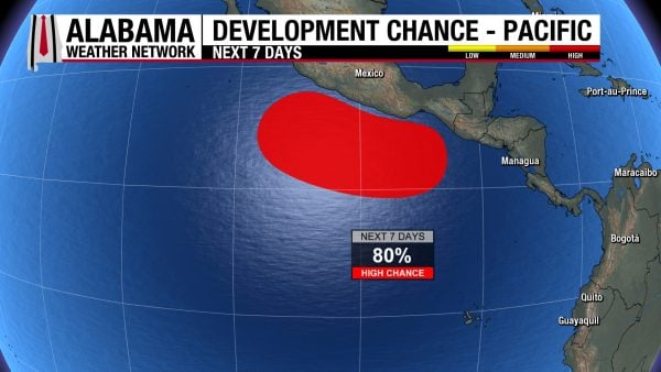
There is also an area of low pressure off the southern coast of Mexico that has an 80% chance of development over the next week.
WET STRETCH AHEAD FOR COAST
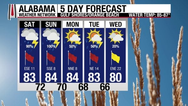
Today and tomorrow feature very high rain chances for the coast, 90% today and 100% tomorrow. This is thanks to very high Gulf moisture being advected into the region. Accompanying the rainy day today, the high will be in the low 80s, skies will be mostly cloudy, and winds will blow from the southeast around 10 mph. This wind flow will keep the rip current risk High and the surf height at 3 to 5 feet. The chance for flash, river, and coastal flooding this weekend is the highest on the coast, so extra precaution should be taken if driving. Rain chances decrease to 50% Monday and Tuesday, and more relief from the rain arrives on Wednesday.
TODAY IN WEATHER HISTORY
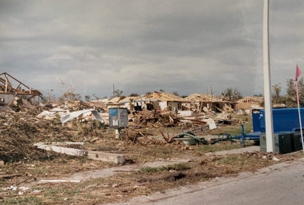
October 3, 1992 – Pinellas Park Tornado
A sprawling low-pressure system moving out of the Gulf of Mexico created a volatile morning across west-central Florida. The system was not a hurricane or even a well-organized tropical storm, but it carried deep tropical moisture and enough wind shear to produce several tornadoes around Tampa Bay. The most destructive touched down in Pinellas Park shortly after 10:30 a.m., cutting through one of Florida’s most densely populated counties.
Rated F3, the tornado carved a path roughly 2.7 miles long and as much as 500 yards wide. It intensified as it crossed Park Royale Village, where mobile homes were torn apart and debris scattered across the neighborhood. Eighty-seven units were destroyed, and another 63 were damaged. Two people were killed there, while a third died in the Beacon Hill subdivision when a garage roof collapsed. Seventy-five people were injured along the tornado’s path.
Aerial photographs taken afterward suggested that the tornado may have contained multiple vortices as it crossed Park Royale. Nearby Beacon Hill suffered strong F3 damage to both concrete-block and wood-frame homes, while warehouses and industrial buildings were heavily damaged. Pinellas Park High School also sustained major damage, with portions of the roof and athletic facilities torn apart. The tornado’s rapid development gave residents little time to react before it swept through neighborhoods and businesses.
The outbreak was not limited to Pinellas Park. An F2 tornado near Largo tore through the Indian Rocks Mobile Home Park, killing another person and damaging numerous trailers. Strong onshore winds associated with the Gulf low also pushed tides four to five feet above normal along portions of Florida’s west coast, producing coastal flooding and major beach erosion in Hillsborough County and around Egmont Key.
Farther northeast, torrential rain became the dominant hazard. Brunswick, Georgia, recorded 10.14 inches, while Jacksonville measured 8.69 inches. Roads and homes flooded as the same broad storm system affected much of north Florida and southern Georgia. Total damage from the event was estimated near $32 million, making the outbreak a striking example of how one disorganized Gulf system could produce tornadoes, coastal flooding, heavy rain, and widespread damage across a large portion of the Southeast.

IMAGE(S) OF THE DAY
It was difficult to choose one image today, so here are two!
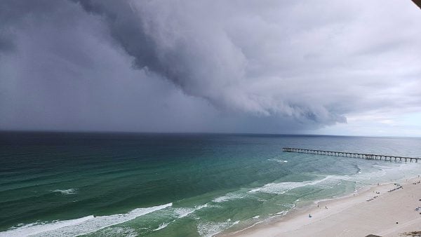
1. Shelf cloud associated with a Special Marine Warning storm in Panama City Beach yesterday afternoon. Credit: Jeff Drake
2. Monarch Butterfly on a Dense Blazing Star in Bay Minette yesterday afternoon. Credit: Ron Lipham