


Resetting the current weather situation as of 10:40.
A severe thunderstorm watch is in effect for the northern third of Alabama until 3 p.m.
Not another derecho!
Oh, yes…it’s going to be another derecho.
A strong mesoscale convective complex was moving across Northwest Alabama. It extends through
…eastern Lawrence
…Winston
…NW Walker
…extreme SE Marion
…Fayette
…southern Lamar
…into northern Pickens Counties
It is moving quickly east southeast at 50 mph.
It is going to increase intensity as it moves into areas where the temperatures are in the lower 80s and dewpoints are in the 70s. Areas north of a line from Carrollton to Centreville to Clanton to Columbus GA should monitor this line. Another severe thunderstorm watch will likely be required.
Warnings for severe thunderstorms cover…
…eastern Lauderdale and Colber
…Lawrence
…SE Marion
…all of Winston
…western Walker
…Fayette
…southeastern Lamar
…NW Tuscaloosa
…and northern Pickens Counties
If you are in the path of this line, prepare for damaging winds of 60 mph or higher, hail, deadly lightning and torrential rains that could cause flooding.
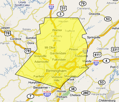
A new severe thunderstorm warning was just issued for Blount and Jefferson Counties. It goes until 1115 a.m. Strong storms are over the Birmingham Metro area and they are intensifying. Watch out for damaging winds, hail, lightning and flooding rains.



