


Daily Weather Briefing
Sunday, March 8, 2026
ALABAMA THIS MORNING
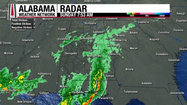
Showers and thunderstorms stretch from central to south Alabama this morning. Central Alabama is just experiencing rain at the moment, while thunderstorms still impact the south, although they are neither strong nor severe. The north and a pocket of western-central Alabama are dry right now, but cloudy. Temperatures range from the lower 60s through north and south-central Alabama, to the mid 60s in the south.
ALABAMA 7 DAY FORECAST
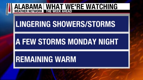
An active spring weather pattern greets us this week. Showers and thunderstorms will continue today but will not be severe. A low chance of severe storms is present Monday as a weak front attempts to move through the state. Scattered showers and thunderstorms occur Tuesday as well. Then, a strong cold front will bring a line of thunderstorms Wednesday, bringing another severe threat with it. Thunderstorms will linger Thursday morning, then the state finally dries out for a few days.
SCATTERED THUNDERSTORMS TODAY
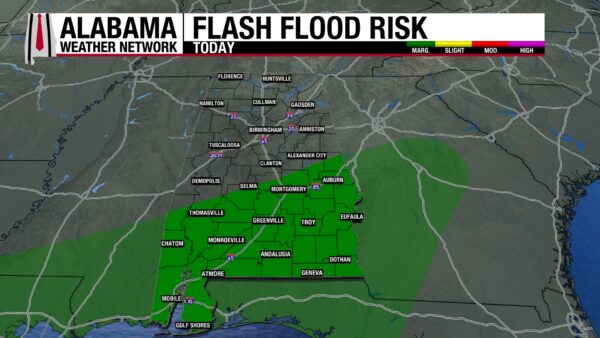
The widespread showers and thunderstorms south will clear out of the state this morning, then scattered thunderstorms will move through the state from west to east today. Instability is limited, so storms will stay sub-severe, but a strong wind gust or downpour is still possible. The south is under a Marginal Risk (1/4) for Excessive Rainfall, meaning that isolated flash flooding is possible. Skies will be overcast statewide. Highs will range from the lower 70s north to the mid 70s south.
A BREAK FROM THE RAIN TONIGHT
Showers will clear out of the state in the evening hours, giving us a nice break from the rain. The sky will stay blanketed by clouds, so lows will range from the upper 50s north, low 60s centrally, and mid 60s south.
 <img
<img
MORE THUNDERSTORMS MONDAY
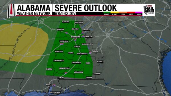
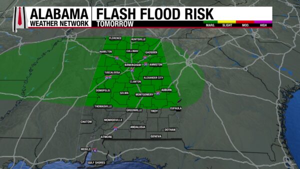
A front will attempt to make its way through the state Monday. This will cause showers and thunderstorms to begin in the afternoon/evening hours. A low threat (Marginal Risk, 1/5) of severe thunderstorms is attached to this system, which will produce damaging winds and potentially large hail. Tornado chances are very low. The most eastern-third of the state and the coast will be the only areas in the state that will not be under the low risk of severe weather. The low flash flooding threat will be north tomorrow. Highs will climb to the upper 70s to lower 80s from north to south.
RAIN TUESDAY
Thunderstorm chances linger Tuesday, but any storms should be scattered and sub-severe in nature. The greater chance for storms is in the morning, as they will be remnants of Monday’s system. Highs will increase from Monday into the upper 70s to lower 80s north, and lower to mid 80s centrally and in the south.
SEVERE STORMS POSSIBLE AGAIN WEDNESDAY
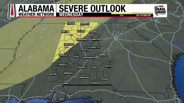
Another, much stronger cold front will approach and enter the state on Wednesday. A few scattered showers are possible before the main, organized line of thunderstorms impacts the state. Damaging wind gusts will be the main threat with the system, but hail and a tornado or two cannot be ruled out. The graphic above means that there is a 15% chance of severe weather occurring in northwest Alabama Wednesday. Timing is still uncertain, but as of right now, the line should move through Wednesday night into Thursday morning. The system will be much stronger in north and central Alabama, while south Alabama will experience weaker effects from the storm. Highs will sit in the lower to mid 80s from north to south.
RAIN EARLY THURSDAY
Thursdays’ set up will be similar to Tuesday’s. Sub-severe showers and thunderstorms will occur throughout the morning before clearing out in the afternoon. It will differ from Tuesday, however, in the fact that highs will be much cooler as the cold front will bring a noticeably cooler airmass to the South. Highs Thursday will top out at the upper 50s north, the mid 60s centrally, and the mid 60s south. These temperatures are very similar to the low temperatures we’ve experienced recently.
DRY PATTERN RETURNS FRIDAY AND SATURDAY
After what will be a much-needed wet week, dry conditions will finally return to the state. Friday, highs will increase quickly into the high 60s to low 70s as skies will be sunny. Clear skies continue Saturday, with highs reaching the 70s statewide.
STORMY DAY ON THE COAST
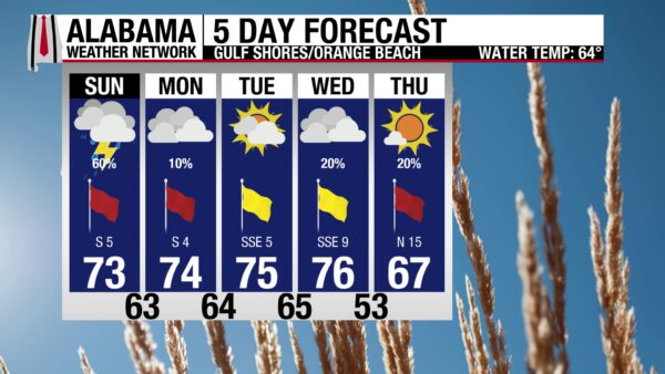
Showers and thunderstorms will occur throughout the day, so a quiet Sunday indoors may be the best plan! The high will be in the lower 70s and winds will come from the southeast/south at 5 mph. The rip current risk is high, and extreme caution should be used if swimming.

WEATHERBRAINS 1051
Two guests from the Storm Prediction Center Bill Bunting and Evan Bentley will talk SPC: tools, new initiatives, and new communication styles are just a few topics that will be covered in tomorrow’s show. Send in your questions and watch the episode here.
TODAY IN WEATHER HISTORY
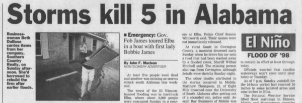
March 8, 1998 – Beaver Dam Creek Flood
After three days of heavy rain, floodwaters from Beaver Dam Creek were sent churning through the small south Alabama town of Elba, as a levee gave way. 2000 of the 4000 residents had to evacuate downtown, as 6 feet of water rushed into the area. Five people died during the event. Unfortunately, very cold temperatures in the middle 20s followed suit only three days later. This made recovery from the event difficult. This was the third flood in the town in eight years, with one occurring in 1990 due to a levee break on the Pea River.
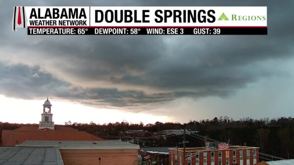
IMAGE OF THE DAY
Our Double Springs Regions Skycam had a unique view of storm clouds as they rolled into the area yesterday!



