


RADAR CHECK: Rain is falling over the northwest corner of Alabama this afternoon, otherwise the rest of the state is generally dry with just a few spotty showers over the northern third of the state. Away from showers temperatures are generally in the 88-92 degree range.

Alabama’s weather won’t change much tomorrow. The day will be hot and humid with a few spotty showers/storms around during the afternoon and evening hours. Very routine weather for June.
Coverage of showers and thunderstorms will increase Sunday over the northern half of the state ahead of a surface front and upper trough. Still, it won’t rain all day, but the rain could be heavy in spots with a good surge of tropical moisture moving northward. Showers across South Alabama Sunday will remain widely scattered.
NEXT WEEK: Global models continue to suggest a good chance of showers and thunderstorms Monday, but mainly along and south of U.S. 278 (Hamilton to Cullman to Gadsden). Drier air will move into the northern quarter of the state, where most places will be rain-free across the Tennessee Valley.
On Tuesday the main coverage of showers and storms will be along and south of U.S. 80 (Demopolis to Montgomery to Opelika) as the drier air continues to sag southward. North Alabama should be generally rain-free with lower humidity levels.
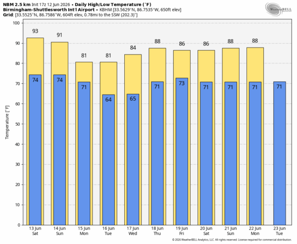
Then, over the latter half of the week, the weather looks routine for June with partly sunny days and a few spotty showers around. Heat levels will be lower next week with highs in the 80s. See the video briefing for maps, graphics, and more details.
TROPICS: Disorganized shower and thunderstorm activity has increased a little near a broad area of low pressure located over the Bay of Campeche. Environmental conditions are forecast to be only marginally conducive for development before the system moves inland over eastern Mexico late tomorrow or Sunday. The system could re-emerge over the northwestern Gulf on Tuesday and Wednesday while interacting with a frontal boundary, but there too, conditions are only expected to be marginally conducive for any development. The chance of development is only 20 percent.
The rest of the Atlantic basin remains quiet.
ON THIS DATE IN 2022: A powerful supercell generated an EF2 tornado that tore through the Bridger-Teton National Forest. The tornado occurred at an astonishing elevation of between 8,000 and 9,000 feet over the Gros Ventre Range. It completely leveled a massive, continuous swath of softwood forest, snapping thousands of mature pine trees at their bases and causing widespread debarking. Because the area was so remote and inaccessible, the full path (2.1 miles long and 360 yards wide) wasn’t completely verified until months later when helicopter footage and satellite data confirmed the undeniable cyclonic tree-fall pattern.
I will be on vacation next week… be sure and follow the Alabama Weather Network! I will be back in service Monday June 22.



