


A solid line of intense thunderstorms is moving into West Alabama at this hour.
Let’s go county by county…
Marion…heavy rain and storms over the western part of the county…but storms to the WSW near Hamilton and back into northern Lamar County AL will affect the rest of the county from Guin east and north over the next hour.
Lamar…strongest storms are northwest of Vernon, moving northeast. Areas around Detroit, Sulligent and Beaverton will be affected by the heaviest storms.
Pickens County…severe storms near to south of Columbus will affect the northern part of Pickens…a severe thunderstorm warning is already in effect for the southern half of Pickens generally south of Carrollton…for an especially suspicious bow looking echo west of Macon MS down to DeKalb MS. High winds very likely with this feature.
Sumter…northern Sumter under warning…expect more warnings for rest of county…the southern part of tat bow echo will affect much of the county with the threat of very high winds. Livingston is in the path.
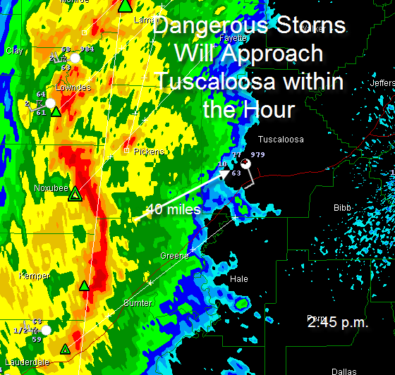
TUSCALOOSA…this bow echo is about 45 minutes from affecting you. Go ahead and be preparing. Leave mobile homes for more substantial structures til the storm passes. In you are at home or in a building, be prepared to go to an interior room on the lowest floor as they pass.
DON’T FORGET…a tornado watch is in effect. Instability levels are high and wind shear is strong, so tornadoes are possible with these strong storms.



