



This afternoon numerous strong thunderstorms have been developing across Alabama. Most of these storms are not severe, but we are seeing a few severe storms. Main threat with these storms continues to be a damaging wind event. This cluster of severe storms will be impacting Highways 82 and 43 in west Alabama. Watch out in and around the cities of Reform, Millport, Fayette and Berry as damaging winds are likely to occur with these storms. There is also a threat for hail; dangerous lightning and intense rain are being reported with all storms today.
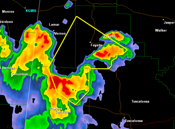
THE NATIONAL WEATHER SERVICE IN BIRMINGHAM HAS ISSUED A
* SEVERE THUNDERSTORM WARNING FOR…
SOUTHERN FAYETTE COUNTY IN WEST CENTRAL ALABAMA…
SOUTHEASTERN LAMAR COUNTY IN WEST CENTRAL ALABAMA…
NORTHEASTERN PICKENS COUNTY IN WEST CENTRAL ALABAMA…
* UNTIL 500 PM CDT
* AT 417 PM CDT…THE NATIONAL WEATHER SERVICE INDICATED A SEVERE
THUNDERSTORM CAPABLE OF PRODUCING DAMAGING WINDS IN EXCESS OF 60
MPH. THIS STORM WAS LOCATED NEAR REFORM…AND MOVING NORTHEAST AT
30 MPH.
* LOCATIONS IMPACTED INCLUDE…
MILLPORT…FAYETTE…KENNEDY…ASHCRAFT CORNER…BELK…BLOOMING
GROVE…BANKSTON AND BERRY.
WINDS OF 60 TO 70 MPH WILL BREAK LARGE TREE LIMBS AND CAUSE SOME
DAMAGE…ESPECIALLY TO SMALLER STRUCTURES.
PRECAUTIONARY/PREPAREDNESS ACTIONS…
FOR YOUR PROTECTION…MOVE TO AN INTERIOR ROOM ON THE LOWEST FLOOR OF
YOUR HOME OR BUSINESS.



