


…THE SEVERE THUNDERSTORM WARNING FOR SOUTH CENTRAL CLEBURNE AND NORTHEASTERN CLAY COUNTIES IS CANCELLED… The storms which prompted the warning have weakened below severe limits, and have exited the warned area. Therefore the warning has been cancelled.
Severe Thunderstorm Warning Continues For Parts Of Clay And Cleburne Counties Until 6:15PM
Jul 6th @ 5:24 pm

…A SEVERE THUNDERSTORM WARNING REMAINS IN EFFECT UNTIL 615 PM CDT FOR SOUTH CENTRAL CLEBURNE AND NORTHEASTERN CLAY COUNTIES… At 548 PM CDT, severe thunderstorms were located along a line extending from near Heflin to near Delta, moving east at 30 mph.
HAZARD…60 mph wind gusts and penny size hail.
SOURCE…Radar indicated.
IMPACT…Expect damage to roofs, siding, and trees. Locations impacted include… Heflin, Delta, Hollis Crossroads, Camp Sequoyah and Chalafinnee.
Severe Thunderstorm Warning Canceled For Parts Of Calhoun County
Jul 6th @ 5:24 pm
…THE SEVERE THUNDERSTORM WARNING FOR SOUTHEASTERN CALHOUN COUNTY IS CANCELLED… The storms which prompted the warning have moved out of the warned area. Therefore, the warning has been cancelled.
Severe Thunderstorm Warning Continues For Parts Of Calhoun, Clay, And Cleburne Counties Until 6:15PM
Jul 6th @ 5:24 pm

…A SEVERE THUNDERSTORM WARNING REMAINS IN EFFECT UNTIL 615 PM CDT FOR SOUTHEASTERN CALHOUN…SOUTHWESTERN CLEBURNE AND NORTHEASTERN CLAY COUNTIES… At 536 PM CDT, severe thunderstorms were located along a line extending from near Oxford Lake to near Delta, moving east at 45 mph.
HAZARD…60 mph wind gusts and penny size hail.
SOURCE…Radar indicated.
IMPACT…Expect damage to roofs, siding, and trees. Locations impacted include… Anniston, Oxford, Heflin, Delta, Mount Cheaha, Dearmanville, Hollis Crossroads, Chalafinnee and Camp Sequoyah.
Severe Thunderstorm Warning Issued For Parts Of Calhoun, Clay, And Cleburne Counties Until 6:15PM
Jul 6th @ 5:24 pm
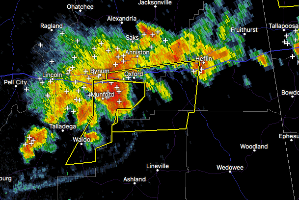

The National Weather Service in Birmingham has issued a
* Severe Thunderstorm Warning for…
Southeastern Calhoun County in east central Alabama…
Southwestern Cleburne County in east central Alabama…
Northeastern Clay County in east central Alabama…
* Until 615 PM CDT
* At 523 PM CDT, a severe thunderstorm was located over Talladega
Municipal Airport, or 9 miles northeast of Talladega, moving east at 30 mph.
HAZARD…60 mph wind gusts and penny size hail.
SOURCE…Radar indicated.
IMPACT…Expect damage to roofs, siding, and trees.
* Locations impacted include…
Anniston, Oxford, Heflin, Hobson City, Anniston Regional Airport, Oxford Lake, Delta, Mount Cheaha, Bynum, Hollis Crossroads, Dearmanville, Chalafinnee, Lake Chinnabee and Camp Sequoyah.



