


…THE SEVERE THUNDERSTORM WARNING FOR NORTH CENTRAL CALHOUN COUNTY
WILL EXPIRE AT 700 PM CDT…
The storm which prompted the warning has weakened below severe
limits, and no longer poses an immediate threat to life or property.
Therefore the warning will be allowed to expire.
A tornado watch remains in effect until 900 PM CDT for northeastern
and east central Alabama.
Severe Thunderstorm Warning Continues For Parts Of Calhoun County Until 7:00PM
Apr 5th @ 6:18 pm

…A SEVERE THUNDERSTORM WARNING REMAINS IN EFFECT UNTIL 700 PM CDT FOR NORTH CENTRAL CALHOUN COUNTY… At 650 PM CDT, a severe thunderstorm was located near Alexandria, or near Jacksonville, moving northeast at 50 mph.
HAZARD…60 mph wind gusts and quarter size hail.
SOURCE…Radar indicated.
IMPACT…Hail damage to vehicles is expected. Expect wind damage to roofs, siding, and trees. Locations impacted include… Anniston, Jacksonville, Saks, Glencoe, Weaver, Alexandria, Jacksonville State University, Sulphur Springs and Wellington.
Severe Thunderstorm Warning Continues For Parts Of Calhoun County Until 7:00PM
Apr 5th @ 6:18 pm

…A SEVERE THUNDERSTORM WARNING REMAINS IN EFFECT UNTIL 700 PM CDT FOR CENTRAL CALHOUN COUNTY… At 637 PM CDT, a severe thunderstorm was located near Ohatchee, or 9 miles west of Saks, moving northeast at 50 mph.
HAZARD…Two inch hail and 60 mph wind gusts.
SOURCE…Radar indicated.
IMPACT…People and animals outdoors will be injured. Expect hail damage to roofs, siding, windows, and vehicles. Expect wind damage to roofs, siding, and trees. Locations impacted include… Anniston, Jacksonville, Saks, Glencoe, Weaver, Ohatchee, Alexandria, Jacksonville State University, Southside, Sulphur Springs and Wellington.
Severe Thunderstorm Warning Canceled For Parts Of St. Clair And Talladega Counties
Apr 5th @ 6:18 pm
…THE SEVERE THUNDERSTORM WARNING FOR NORTH CENTRAL TALLADEGA AND EAST CENTRAL ST. CLAIR COUNTIES IS CANCELLED… The severe thunderstorm which prompted the warning has moved out of the warned area. Therefore, the warning has been cancelled. However, another storm is moving in from the southwest and a separate severe thunderstorm warning is in effect. A tornado watch remains in effect until 900 PM CDT for northeastern, east central Alabama.
Severe Thunderstorm Warning Continues For Parts Of Calhoun, St. Clair, And Talladega Counties Until 7:00PM
Apr 5th @ 6:18 pm

…A SEVERE THUNDERSTORM WARNING REMAINS IN EFFECT UNTIL 700 PM CDT FOR NORTH CENTRAL TALLADEGA…WESTERN CALHOUN AND EAST CENTRAL ST. CLAIR COUNTIES… At 623 PM CDT, a severe thunderstorm was located over Riverside, or 7 miles northeast of Pell City, moving northeast at 50 mph.
HAZARD…Tennis ball size hail and 60 mph wind gusts.
SOURCE…Radar indicated.
IMPACT…People and animals outdoors will be injured. Expect hail damage to roofs, siding, windows, and vehicles. Expect wind damage to roofs, siding, and trees. Locations impacted include… Anniston, Pell City, Jacksonville, Fort McClellan, Saks, Lincoln, Glencoe, Weaver, Riverside, Ragland, Ohatchee, Honda Manufacturing Of Alabama, Alexandria, Jacksonville State University, Southside, Neely Henry Dam, Sulphur Springs and Wellington.
Severe Thunderstorm Warning Issued For Parts Of Calhoun, St. Clair, And Talladega Counties Until 7:00PM
Apr 5th @ 6:18 pm
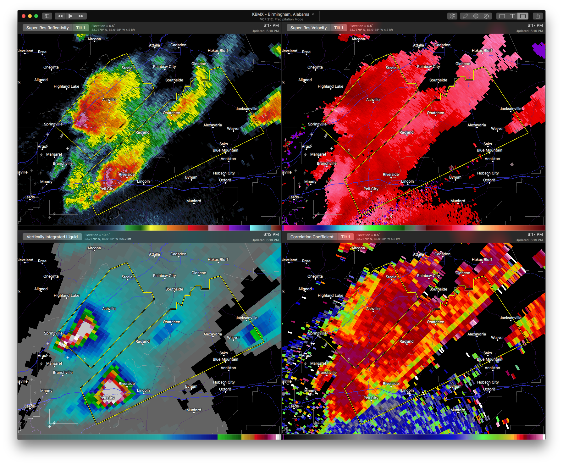

The National Weather Service in Birmingham has issued a
* Severe Thunderstorm Warning for…
North central Talladega County in east central Alabama…
Western Calhoun County in east central Alabama…
Southeastern St. Clair County in Alabama…
* Until 700 PM CDT
* At 617 PM CDT, a severe thunderstorm was located over Pell City, moving northeast at 50 mph.
HAZARD…Golf ball size hail and 60 mph wind gusts.
SOURCE…Radar indicated.
IMPACT…People and animals outdoors will be injured. Expect hail damage to roofs, siding, windows, and vehicles. Expect wind damage to roofs, siding, and trees.
* Locations impacted include…
Anniston, Pell City, Jacksonville, Fort McClellan, Saks, Lincoln, Glencoe, Weaver, Riverside, Ragland, Ohatchee, Honda Manufacturing
Of Alabama, Alexandria, Jacksonville State University, Southside, St. Clair County Airport, Neely Henry Dam, Sulphur Springs, Cropwell and Wellington.



