


…A SEVERE THUNDERSTORM WARNING REMAINS IN EFFECT UNTIL 815 PM CDT FOR EASTERN CHILTON AND EASTERN SHELBY COUNTIES… At 757 PM CDT, severe thunderstorms were located along a line extending from near Logan Martin Lake to Marbury, moving east at 40 mph.
HAZARD…60 mph wind gusts.
SOURCE…Radar indicated.
IMPACT…Expect damage to roofs, siding, and trees. Locations impacted include… Clanton, Childersburg, Wilsonville, Vincent, Harpersville, Mitchell Lake, Lay Lake Dam, Verbena, Lay Lake, Beeswax Creek Park, Alabama 4H Center, Waxahatchee Creek, Kelley Branch, Mitchell Dam, Spring Creek, Gaston Steam Plant, Cooper and Shelby Shores.
A Severe Thunderstorm Warning Remains In Effect Until 8:15 PM CDT For Central Chilton And Shelby Counties
Apr 18th @ 7:44 pm

…A SEVERE THUNDERSTORM WARNING REMAINS IN EFFECT UNTIL 815 PM CDT FOR CENTRAL CHILTON AND SHELBY COUNTIES… At 744 PM CDT, severe thunderstorms were located along a line extending from near Vandiver to near Verbena, moving east at 45 mph.
HAZARD…60 mph wind gusts.
SOURCE…Radar indicated.
IMPACT…Expect damage to roofs, siding, and trees. Locations impacted include… Leeds, Calera, Chelsea, Clanton, Childersburg, Columbiana, Jemison, Wilsonville, Vincent, Thorsby, Harpersville, Westover, Gap Of The Mountain, Vandiver, Verbena, Greystone, Plecher, Highland Lakes, Mitchell Lake and Lay Lake Dam.
A Severe Thunderstorm Warning Remains In Effect Until 8:15 PM CDT For Chilton And Shelby Counties
Apr 18th @ 7:18 pm

…A SEVERE THUNDERSTORM WARNING REMAINS IN EFFECT UNTIL 815 PM CDT FOR CHILTON AND SHELBY COUNTIES… At 716 PM CDT, severe thunderstorms were located along a line extending from Patton Creek to near Parnell, moving east at 45 mph.
HAZARD…60 mph wind gusts.
SOURCE…Radar indicated.
IMPACT…Expect damage to roofs, siding, and trees. Locations impacted include… Hoover, Alabaster, Pelham, Helena, Leeds, Calera, Chelsea, Clanton, Montevallo, Childersburg, Columbiana, Jemison, Wilsonville, Indian Springs Village, Vincent, Thorsby, Harpersville, Westover, Maplesville and Wilton.
Severe Thunderstorm Warning Issued For Parts Of Chilton And Shelby Counties Until 8:15PM
Apr 18th @ 6:54 pm
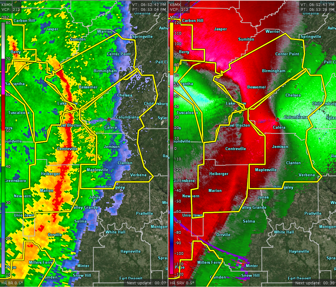

The National Weather Service in Birmingham has issued a
* Severe Thunderstorm Warning for…
Chilton County in central Alabama…
Shelby County in central Alabama…
* Until 815 PM CDT.
* At 653 PM CDT, severe thunderstorms were located along a line extending from near Tannehill Ironworks State Park to 9 miles west of Paul M Grist State Park, moving east at 45 mph.
HAZARD…60 mph wind gusts.
SOURCE…Radar indicated.
IMPACT…Expect damage to roofs, siding, and trees.
* Locations impacted include…
Hoover, Alabaster, Pelham, Helena, Leeds, Calera, Chelsea, Clanton, Montevallo, Childersburg, Columbiana, Jemison, Wilsonville, Indian
Springs Village, Vincent, Thorsby, Harpersville, Westover, Maplesville and Wilton.



