


…THE SEVERE THUNDERSTORM WARNING FOR EAST CENTRAL ELMORE AND SOUTH
CENTRAL TALLAPOOSA COUNTIES WILL EXPIRE AT 645 PM CDT…
The storm which prompted the warning has moved out of the area.
Therefore, the warning will be allowed to expire.
A Severe Thunderstorm Watch remains in effect until 900 PM CDT for
southeastern and east central Alabama.
A Severe Thunderstorm Warning Remains In Effect Until 6:45 PM CDT For South Central Tallapoosa County
Mar 25th @ 6:24 pm

…A SEVERE THUNDERSTORM WARNING REMAINS IN EFFECT UNTIL 645 PM CDT FOR SOUTH CENTRAL TALLAPOOSA COUNTY… At 623 PM CDT, a severe thunderstorm was located over Liberty City, or 7 miles northwest of Notasulga, moving east at 40 mph.
HAZARD…60 mph wind gusts and quarter size hail.
SOURCE…Radar indicated.
IMPACT…Hail damage to vehicles is expected. Expect wind damage to roofs, siding, and trees. Locations impacted include… Tallassee, Martin Dam, Liberty City, Southern Lake Martin, Reeves Airport, Tallapoosa City, Yates Dam, Reeltown and Yates Reservoir.
A Severe Thunderstorm Warning Remains In Effect Until 6:45 PM CDT For East Central Elmore And South Central Tallapoosa Counties
Mar 25th @ 6:23 pm

…A SEVERE THUNDERSTORM WARNING REMAINS IN EFFECT UNTIL 645 PM CDT FOR EAST CENTRAL ELMORE AND SOUTH CENTRAL TALLAPOOSA COUNTIES… At 623 PM CDT, a severe thunderstorm was located over Liberty City, or near Notasulga, moving east at 45 mph.
HAZARD…60 mph wind gusts and quarter size hail.
SOURCE…Radar indicated.
IMPACT…Hail damage to vehicles is expected. Expect wind damage to roofs, siding, and trees. Locations impacted include… Tallassee, Eclectic, Martin Dam, Liberty City, Southern Lake Martin, Reeves Airport, Tallapoosa City, Claud, Yates Dam, Reeltown and Yates Reservoir.
Severe Thunderstorm Warning Issued For Parts Of Elmore And Tallapoosa Counties Until 6:45PM
Mar 25th @ 5:54 pm
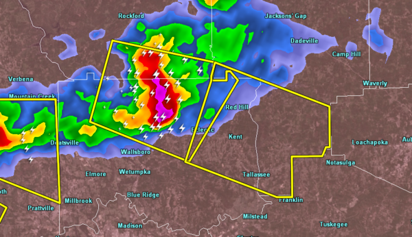

The National Weather Service in Birmingham has issued a
* Severe Thunderstorm Warning for…
Northeastern Elmore County in east central Alabama…
Southwestern Tallapoosa County in east central Alabama…
* Until 645 PM CDT.
* At 554 PM CDT, a severe thunderstorm was located over Santuck, or 7 miles south of Equality, moving east at 45 mph.
HAZARD…70 mph wind gusts and quarter size hail.
SOURCE…Radar indicated.
IMPACT…Hail damage to vehicles is expected. Expect considerable tree damage. Wind damage is also likely to mobile homes, roofs, and outbuildings.
* Locations impacted include…
Tallassee, Eclectic, Martin Dam, Liberty City, Reeves Airport, Western Lake Martin, Tallapoosa City, Southern Lake Martin, Kowaliga Bridge, Eastern Lake Martin, Claud, Yates Dam, Reeltown and Yates Reservoir.



