


…THE SEVERE THUNDERSTORM WARNING FOR SOUTHEASTERN MARION AND
NORTHERN FAYETTE COUNTIES WILL EXPIRE AT 145 PM CDT…
The storms which prompted the warning have moved out of the area.
Therefore the warning will be allowed to expire.
A tornado watch remains in effect until 800 PM CDT for northwestern,
west central Alabama.
Severe Thunderstorm Warning Continues For Parts Of Fayette And Marion Counties Until 1:45PM
Jun 23rd @ 12:52 pm

…A SEVERE THUNDERSTORM WARNING REMAINS IN EFFECT UNTIL 145 PM CDT FOR SOUTHEASTERN MARION AND NORTHERN FAYETTE COUNTIES… At 135 PM CDT, severe thunderstorms were located along a line extending from near Haleyville to near Lynn to near Eldridge to near Glen Allen, moving northeast at 45 mph.
HAZARD…60 mph wind gusts.
SOURCE…Radar indicated.
IMPACT…Expect damage to roofs, siding, and trees. Locations impacted include… Winfield, Fayette, Brilliant, Glen Allen, Belk, Bluff, Bazemore, Richard Arthur Field, Bevill State College Fayette, Hubbertville, Fowlers Crossroads, Texas and Piney Grove.
Severe Thunderstorm Warning Continues For Parts Of Fayette And Marion Counties Until 1:45PM
Jun 23rd @ 12:52 pm

…A SEVERE THUNDERSTORM WARNING REMAINS IN EFFECT UNTIL 145 PM CDT FOR SOUTHEASTERN MARION AND NORTHERN FAYETTE COUNTIES… At 128 PM CDT, severe thunderstorms were located along a line extending from near Haleyville to near Lynn to near Eldridge to near Glen Allen, moving northeast at 45 mph.
HAZARD…60 mph wind gusts.
SOURCE…Radar indicated.
IMPACT…Expect damage to roofs, siding, and trees. Locations impacted include… Winfield, Fayette, Guin, Brilliant, Glen Allen, Belk, Gu- Win, Bluff, Twin, Tucker, Bazemore, Wayside, Richard Arthur Field, Bevill State College Fayette, Hubbertville, Fowlers Crossroads, Texas and Piney Grove.
Severe Thunderstorm Warning Continues For Parts Of Fayette And Marion Counties Until 1:45PM
Jun 23rd @ 12:52 pm

…A SEVERE THUNDERSTORM WARNING REMAINS IN EFFECT UNTIL 145 PM CDT FOR EASTERN MARION AND NORTHERN FAYETTE COUNTIES… At 122 PM CDT, severe thunderstorms were located along a line extending from near Hackleburg to near Lake Buttahatchee to near Glen Allen to near Bluff, moving northeast at 50 mph.
HAZARD…60 mph wind gusts.
SOURCE…Radar indicated.
IMPACT…Expect damage to roofs, siding, and trees. Locations impacted include… Winfield, Fayette, Haleyville, Guin, Hackleburg, Brilliant, Glen Allen, Belk, Gu- Win, Bluff, Brinn, Lake Buttahatchee, Bear Creek, Twin, Tucker, Wayside, Richard Arthur Field, Piney Grove, Bazemore and Tessner.
Severe Thunderstorm Warning Continues For Parts Of Fayette And Marion Counties Until 1:45PM
Jun 23rd @ 12:52 pm

…A SEVERE THUNDERSTORM WARNING REMAINS IN EFFECT UNTIL 145 PM CDT FOR MARION AND NORTHERN FAYETTE COUNTIES… At 115 PM CDT, severe thunderstorms were located along a line extending from near Brinn to near Brilliant to near Bluff to near Blooming Grove, moving east at 40 mph.
HAZARD…60 mph wind gusts.
SOURCE…Radar indicated.
IMPACT…Expect damage to roofs, siding, and trees. Locations impacted include… Hamilton, Winfield, Fayette, Haleyville, Guin, Hackleburg, Brilliant, Glen Allen, Belk, Gu- Win, Bluff, Brinn, Lake Buttahatchee, Bear Creek, Twin, Tucker, Wayside, Richard Arthur Field, Piney Grove and Bazemore.
Severe Thunderstorm Warning Issued For Parts Of Fayette And Marion Counties Until 1:45PM
Jun 23rd @ 12:52 pm
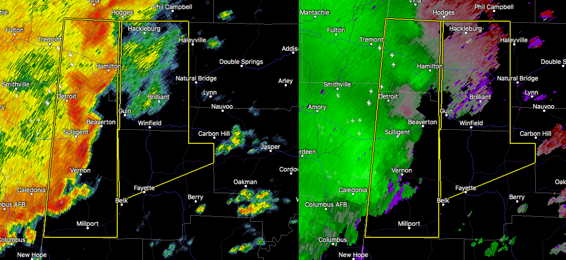

The National Weather Service in Birmingham has issued a
* Severe Thunderstorm Warning for…
Marion County in northwestern Alabama…
Northern Fayette County in west central Alabama…
* Until 145 PM CDT
* At 1251 PM CDT, severe thunderstorms were located along a line extending from 6 miles north of Weston to near Hamilton to near
Beaverton to 6 miles east of Caledonia, moving northeast at 45 mph.
HAZARD…60 mph wind gusts.
SOURCE…Radar indicated.
IMPACT…Expect damage to roofs, siding, and trees.
* Locations impacted include…
Hamilton, Winfield, Fayette, Haleyville, Guin, Hackleburg, Brilliant, Glen Allen, Belk, Gu-
Win, Bluff, Brinn, Lake Buttahatchee, Bear Creek, Twin, Tucker, Wayside, Richard Arthur Field, Piney Grove and Bazemore.



