


…A SEVERE THUNDERSTORM WARNING REMAINS IN EFFECT UNTIL 130 PM CST FOR SOUTHEASTERN LIMESTONE AND NORTHWESTERN MORGAN COUNTIES… At 106 PM CST, a severe thunderstorm was located near Trinity, or 7 miles northwest of Decatur, moving east at 55 mph. This storm has produced widespread damage due to hail in the past 30 minutes.
HAZARD…Ping pong ball size hail and 60 mph wind gusts.
SOURCE…Radar indicated.
IMPACT…People and animals outdoors will be injured. Expect hail damage to roofs, siding, windows, and vehicles. Expect wind damage to roofs, siding, and trees. Locations impacted include… Decatur, Madison, Athens, Trinity, Tanner, Mooresville, Belle Mina, French Mill, Ripley and Capshaw.
Severe Thunderstorm Warning Canceled For Parts Of Lawrence County Until 12:00AM
Mar 1st @ 12:54 pm
…THE SEVERE THUNDERSTORM WARNING FOR NORTHEASTERN LAWRENCE COUNTY
IS CANCELLED…
The severe thunderstorm which prompted the warning has moved east of
the area. Therefore, the warning has been cancelled.
A tornado watch remains in effect until 600 PM CST for north central,
northeastern and northwestern Alabama…and Middle Tennessee.
Severe Thunderstorm Warning Canceled For Parts Of Lawrence County Until 12:00AM
Mar 1st @ 12:54 pm
…THE SEVERE THUNDERSTORM WARNING FOR NORTHEASTERN LAWRENCE COUNTY
IS CANCELLED…
The severe thunderstorm which prompted the warning has moved east of
the area. Therefore, the warning has been cancelled.
A tornado watch remains in effect until 600 PM CST for north central,
northeastern and northwestern Alabama…and Middle Tennessee.
Severe Thunderstorm Warning Issued For Parts Of Lawrence, Limestone, And Morgan Counties until 1:30 PM
Mar 1st @ 12:54 pm
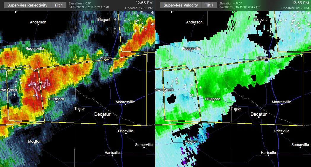

The National Weather Service in Huntsville Alabama has issued a
* Severe Thunderstorm Warning for…
Southern Limestone County in north central Alabama…
Northwestern Morgan County in north central Alabama…
Northeastern Lawrence County in northwestern Alabama…
* Until 130 PM CST
* At 1253 PM CST, a severe thunderstorm was located over Courtland, or 13 miles north of Moulton, moving east at 55 mph.
HAZARD…Ping pong ball size hail and 60 mph wind gusts.
SOURCE…Radar indicated.
IMPACT…People and animals outdoors will be injured. Expect hail damage to roofs, siding, windows, and vehicles. Expect wind damage to roofs, siding, and trees.
* Locations impacted include…
Decatur, Madison, Athens, Trinity, Town Creek, Courtland, Tanner, North Courtland, Hillsboro and Mooresville.



