


…A SEVERE THUNDERSTORM WARNING REMAINS IN EFFECT UNTIL 700 PM CDT FOR CENTRAL TUSCALOOSA COUNTY… At 632 PM CDT, severe thunderstorms were located along a line extending from 7 miles northeast of Samantha to near Brookwood to near Low Gap, moving east at 45 mph.
HAZARD…70 mph wind gusts.
SOURCE…Radar indicated.
IMPACT…Expect considerable tree damage. Damage is likely to mobile homes, roofs, and outbuildings. Locations impacted include… Lake View, Brookwood, Coaling, Vance, Bull City, Abernant, Samantha, Lake Wildwood, Deerlick Creek Campgrounds, Mercedes Benz Of Alabama, Bankhead Lock And Dam, North Bibb, Whitson, Lake Tuscaloosa, East Brookwood, Windham Springs, Peterson, Lake Harris, Hagler and Lake Nicol.
Severe Thunderstorm Warning Issued For Parts Of Tuscaloosa County Until 7:00PM
Apr 18th @ 6:15 pm
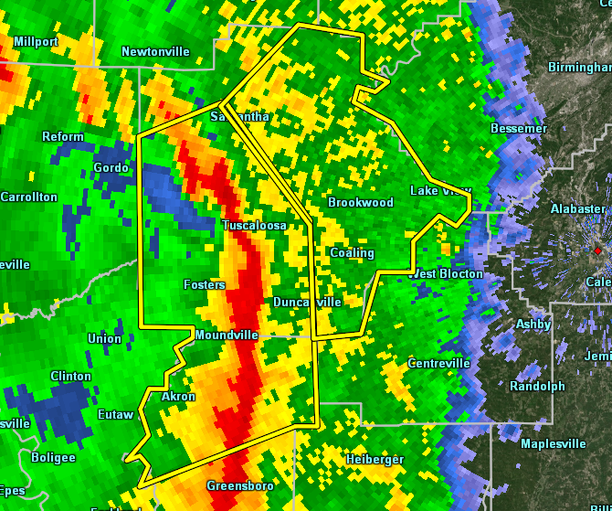

The National Weather Service in Birmingham has issued a
* Severe Thunderstorm Warning for…
Central Tuscaloosa County in west central Alabama…
* Until 700 PM CDT.
* At 615 PM CDT, severe thunderstorms were located along a line extending from near Lake Lurleen State Park to Tuscaloosa to 10 miles southeast of Moundville, moving east at 50 mph.
HAZARD…60 mph wind gusts.
SOURCE…Radar indicated.
IMPACT…Expect damage to roofs, siding, and trees.
* Locations impacted include…
Lake View, Brookwood, Coaling, Vance, Tannehill Ironworks State
Park, Bull City, Abernant, Samantha, Lake Wildwood, Deerlick Creek
Campgrounds, Mercedes Benz Of Alabama, Bankhead Lock And Dam, North
Bibb, Whitson, Lake Tuscaloosa, East Brookwood, Windham Springs, Peterson, Lake Harris and Hagler.



