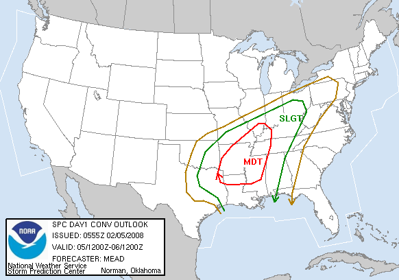
SPC has issued the new day 1 convective outlook. It shows much of northern and western Alabama in a slight risk for severe storms today and tonight, with moderate risk to our west. To read the SPC outlook, click here.
It looks like the system may have slowed down a little. This is probably the reason for the westward shift in the moderate risk. The main squall line may not reach Birmingham until after midnight, but the threat for scattered severe storms will be in place ahead of the line, as early as this afternoon.
There are some factors that make the forecast more difficult. A warm layer aloft, called a “cap”, is in place now, which tends to suppress thunderstorm development, at least for a while. Take a look at the 00 UTC BMX balloon data.

The layer of warmer air near 800 mb would cause any updraft to get stopped there. Now, with the upper level dynamics coming in, this air could get cooled, weakening the cap tomorrow. If the cap stays in place, it can prevent storms altogether until the main squall line arrives later tonight. This is an unknown.
Another factor is the temperature today. If there is enough low-level moisture to keep it cloudy, as the NAM and GFS indicate, we may stay in the 60s most of the day, limiting the instability and storm intensity somewhat. However, if the sun comes out for a few hours, temperatures will rise well into the 70s, causing much more unstable air, and increasing the chances of storms ahead of the main line this afternoon and evening.
Either way, a line of intense storms will move through Alabama late tonight and early tomorrow morning. With this line, expect mainly damaging winds, but maybe some tornadoes. Depending on the amount of sunshine we get today and how much cooling occurs aloft, storms could form ahead of the main line. These storms would be more dangerous.
There is a lot of uncertainty in the forecast, so keep a source of weather information handy today and all night tonight.