


As James points out below, SPC has now placed parts of Mississippi and Louisiana under moderate risk of severe weather this afternoon, and numerous tornado warnings have already been in effect to our west. Radar shows a line of intense storms in southern Arkansas and northern Louisiana, and additional supercell storms ahead of the line over Louisiana.
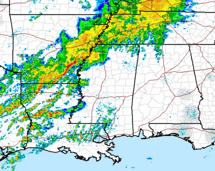
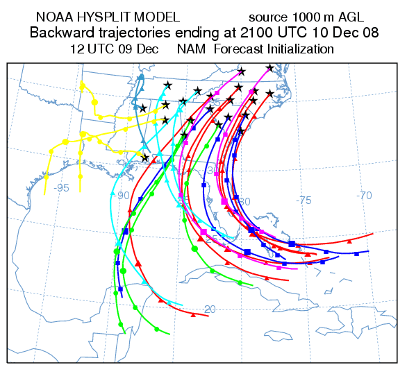
These storms are out ahead of a strong cold front and upper level trough, and will move into Mississippi this afternoon. Southerly flow ahead of the storm is transporting warm, humid air into Alabama. Winds have been gusting 20 to 30 mph over central Alabama this morning. This is helping to bring air from well south in the Gulf into Alabama. Here are the latest air parcel trajectories (where individual air parcels will go over a 33-hour period). Notice that air is coming all the way from the Yucatan Peninsula and southern Gulf into Alabama.
Models continue to be aggressive with the wind fields over Alabama tonight. A secondary disturbance is expected to form over Louisiana/Mississippi this evening, intensifying wind over Alabama. Models predict background winds of 70-80 mph at 4,000 feet over a large part of north Alabama tonight. Not only will this mean plenty of wind shear (helicity above 400 m2/s2, enough to cause rotating storms), but it will also mean that thunderstorm downdrafts will easily transport 60 mph wind to the surface, causing straight-line wind damage. This should be the main threat over Alabama tonight, with trees and powerlines probably going down.
Relatively cool surface temperatures (the system will come through during the night) will limit instability over Alabama. This will hopefully keep a widespread outbreak of tornadoes from occurring this far NE. With helicity over 400 though, we’ll have to watch for a few isolated tornadoes here. We’ll probably be under a severe thunderstorm or tornado watch, at least in west Alabama, by 5 pm. The main threat for BHM is between 10 pm and 4 am. Storms may move into west Alabama by 8 pm.
With the isolated tornado threat looking a little higher now, and widespread straight-line wind damage likely, this will be a night to keep an eye on the weather. Make sure to keep your NOAA Weather Radio in standby mode when you go to bed tonight. And, if severe weather begins to occur, James, Jason, Ashley, Brian, and I will be on ABC 33/40.



