


The Storm Prediction Center has included a large part of Central Alabama in the Day One Slight Risk Outlook.
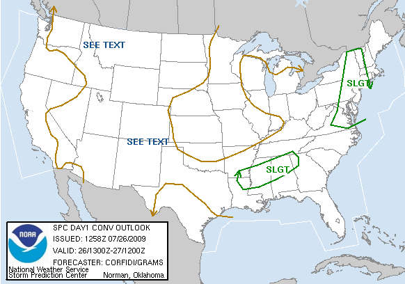
Dewpoints have risen into the upper 60s and lower 70s across North and Central Alabama, so the moisture is in place. It is not excessive, running about 1.40 inches this morning on the BMX sounding, with some dry air in place aloft. That dry air may play a role in damaging wind gusts this afternoon, however.
There is no shortage of warm temperatures, with readings in the middle and upper 80s.
There are quite a few clouds in the I-50 corridor, but sufficient sunshine is still present to push readings to near or above 90 in most spots.
Instability levels will be fairly strong, with CAPE values running to around 3500 j/kg and lifted indices around -6C. This will provide the high octane fuel for storms that develop as the front approaches and the heating of the day peaks.
Right now…radars are clear for the most part across Alabama. An upper disturbance is near Tupelo MS. It is rotating toward NW Alabama. The storms associated with this disturbance have become a mesoscale complex that it is diving into South Central Mississippi.
The front is currently fairly stationary over the Missouri Bootheel. It is expected to begin pushing southeast again later today.
Showers and storms will develop in the unstable air across North and Central Alabama this afternoon and continue through the overnight. Some of the storms could be strong to severe with damaging winds the greatest threat. Be alert to the lightning also. It will be intense.
Go into an enclosed building or house if a thunderstorm approaches you. Cars afford protection from lightning, but can be severely damaged by falling trees.
Please stay weather aware this afternoon and pay attention to storms that develop in your area or move your way.



