


Radar indicates that most of the showers and thunderstorms associated with the first upper level disturbance are now moving into Georgia and south Alabama. The latest high-resolution visible satellite image shows clearing skies to our west over much of Mississippi, and now entering west Alabama. The sun may be out in BHM by 2 pm. Assuming the sun comes out, temperatures will climb quickly into the 70s.
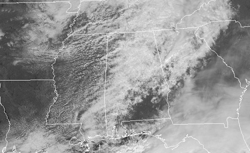
At the same time, SW flow will bring in moisture. Flow will not be directly off the Gulf, so dewpoints may only reach 60 over central Alabama later this afternoon. However, with cold temperatures aloft, the air will become unstable, with CAPES 1000-2000 J/kg.
A very difficult forecast. The air will be very unstable this afternoon, but there won’t be any fronts or upper-level waves to trigger storms, and wind shear is decreasing. A few scattered storms may form, and the ones that do form may become severe, with large hail and damaging wind as the main threats.
Later tonight, as another upper-level disturbance and surface low move out of Oklahoma, wind shear will increase, and a more widespread threat of strong storms will develop from Arkansas into Mississippi, and some storms may develop into Alabama tonight. By Saturday morning, a warm cap will be in place, suppressing thunderstorms over Alabama.
I know this forecast is a little vague. We’ll keep watching it. Keep up with the weather this afternoon and evening, and plug in the NOAA weather radio before bed tonight.



