


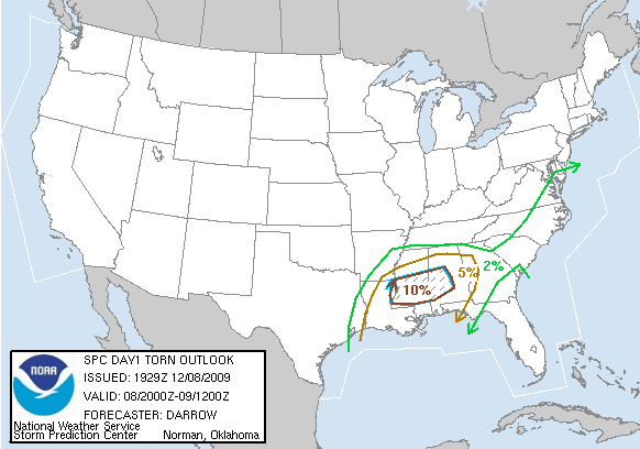
SPC Probability of tornado within 25 miles of a point
A severe weather threat is developing across Mississippi and Alabama this afternoon and tonight, as a strong low pressure area moves through the Ohio River Valley and a cold front approaches from the NW. For a while today, thunderstorms along the coast preventing Gulf air from moving inland. But, with that convection now moving through north Alabama, the warm front has surged northward into western MS and southern AL:

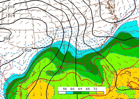
Dewpoints
Dewpoints in the 70s are across Louisiana now, with mid 60s as far NE as Jackson, MS and SW AL. We already have strong southerly flow, with VAD wind profiles from the NWS radar at Birmingham showing southerly winds at 60 mph near 3,000 feet. These winds will likely increase overnight as the big storm to our north intensifies, with winds at 850 mb (about 4,000 feet above ground) expected to reach 75 mph by late this evening.
These strong wind fields will not only bring the very moist air from the Gulf farther north, into much of west and central Alabama this evening, but will also provide very strong wind shear, with helicity values expected to be over 500 m2/s2 tonight. So, any storms that do form will have the potential to rotate.
The big limiting factor is instability. It is not that cold at upper-levels, and with no sunshine surface temperatures will only warm due to southerly winds. Still, temperatures and dewpoints should rise to near 65 as far north as Fayette, Cullman, and Anniston tonight, so the air will be at least a little unstable. As James has pointed out, this is a classic winter time severe weather scenario, with low instability but very high wind shear.
There will be a risk of supercells and tornadoes out ahead of the cold front this evening and tonight, especially over the western half of our area, south of I-20 and west of I-65. A squall line should form to our west by midnight, moving through between midnight and 6 am. There will still be some risk of tornadoes with the line, but the main threat will be damaging straight-line winds, as it won’t take much of a downdraft to bring down the 75 mph winds just 4,000 feet off the ground.
Expect a tornado watch to be issued by 6 or 7 pm. This will be a night to keep the NOAA weather radio and standby, and keep a close eye on the weather.
For your meteorological consulting needs, Coleman and Peters, LLC, can provide you with accurate, detailed information and analysis on past storms, lightning, flooding, and wind damage. Please call us at (205) 568-4401.



