


RADAR CHECK: Showers and thunderstorms continue to develop over the northern half of Alabama this afternoon. While the rain is not as widespread or as intense as yesterday, some spots are still getting a heavy tropical downpour. A flash flood watch remains in effect for much of North/Central Alabama.
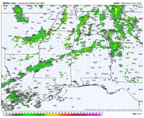
South Alabama is rain-free this afternoon with temperatures approaching 90 degrees in many areas.
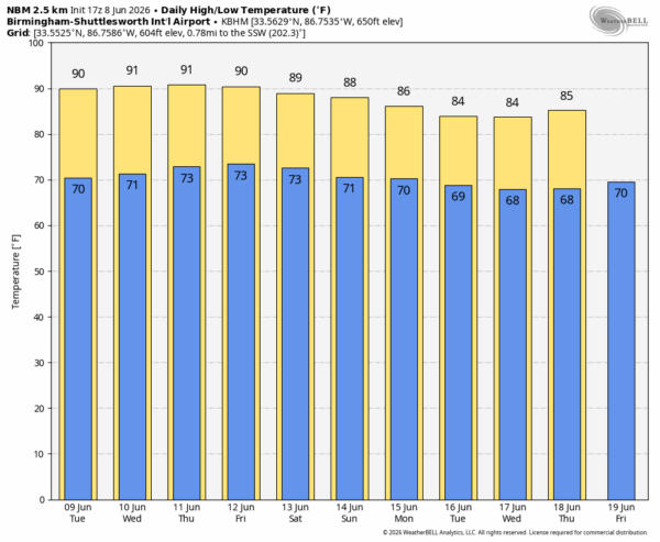
REST OF THE WEEK: Understand we are in the time of the year when you will have the risk of a pop-up afternoon shower or storm just about every afternoon, and that chance will stay in the forecast daily. But, they should be fewer in number after today as an upper ridge rebuilds across the Deep South. This will also mean higher heat levels; expect highs in the upper 80s and low 90s with a mix of sun and clouds each day.
THE ALABAMA WEEKEND: The ridge weakens again, the air aloft will be a little colder, and the air more unstable. So, scattered showers and thunderstorms could be a little more numerous Saturday and Sunday. Highest chance of a shower or storm will come from noon to midnight, and highs will be in the 86-91 degree range. The sun will be out at times, and the weekend won’t be a “wash-out” at all.
NEXT WEEK: Global models suggest the pattern will favor scattered to numerous showers and storms daily… See the video briefing for maps, graphics, and more details.
TROPICS: Tropical storm formation is not expected across the Atlantic basin for at least the next seven days.
ON THIS DATE IN 1989: An F1 tornado moved through Orange Beach, injuring ten people. One home was destroyed and 5 sustained major damage. A total of 17 homes received minor damage. One mobile home was destroyed and another mobile home was damaged. To the west, eight tornadoes were spawned in southeast Louisiana during the pre-dawn hours that day.
Look for the next video briefing here by 6:00 a.m. tomorrow…



