


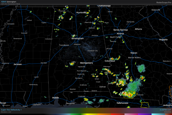
RADAR CHECK: We have a classic case of random, scattered showers and thunderstorms across Alabama this afternoon. A few spots are seeing heavy rain, gusty winds, and frequent lightning, but most places are hot and dry with temperatures in the mid 90s. Scattered storms end tonight.
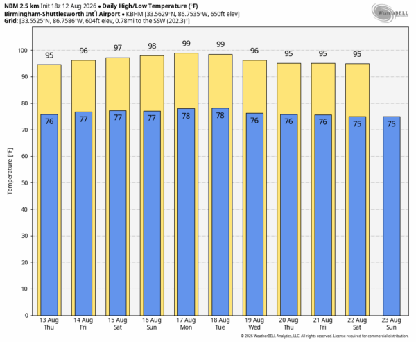
An upper ridge will strengthen over the Deep South in coming days, which will set the stage for sizzling summer days with only isolated afternoon storms tomorrow through the weekend. Highs will be in the mid to upper 90s, and the heat index will exceed 100 with the humid, tropical air in places.
The ridge stays parked over the region through next week, meaning more of the same. Partly sunny, hot, humid days with isolated afternoon storms. Highs next week will be in the upper 90s Monday and Tuesday, followed by mid 90s over the latter half of the week… See the video briefing for maps, graphics, and more details.
TROPICS: Tropical Storm Cristobal has formed in the North Atlantic. This is a weak, junk, short lived system; the center is 880 miles west of the Azores. Sustained winds are 45 mph based on satellite estimates. Cristobal will dissipate tomorrow over colder water far from land.

Elsewhere, an area of showers and thunderstorms associated with a tropical wave (Invest 92L) is located about 950 miles west-southwest of the Cabo Verde
Islands. Environmental conditions are forecast to be conducive for development during the next couple of days, and a tropical depression will likely form while the system moves westward to west-northwestward across the central tropical Atlantic. While the chance of development is 80 percent, most global models show this system dissipating near the Leeward Islands in 4 days or so due to strong winds aloft/shear.
Another wave trails 92L in the eastern Atlantic, NHC gives it a 40 percent chance of development as it moves west/northwest.
It is important to note we expect no tropical storms or hurricane near the contiguous U.S. for at least the next 7-10 days.

ON THIS DATE IN 2007: An intense heat wave was underway across Alabama. Highs on August 12, 2007 included 106 in Montgomery, 105 in Tuscaloosa, 102 at Birmingham and Muscle Shoals, and 100 at Anniston. It was the state’s most severe heat wave since 1980.
Look for the next video briefing here by 6:00 a.m. tomorrow…



