


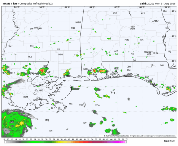
RADAR CHECK: Most of Alabama is rain-free this afternoon with temperatures in the 90s. We note a few isolated showers and storms over the southwest counties moving westward. Those will end after sunset.
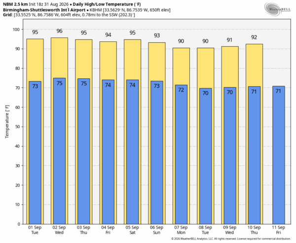
Meteorological fall begins tomorrow, but it sure won’t feel like it as temperatures will stay well into the 90s this week across Alabama and the Deep South. Afternoon highs will be in the 92-97 degree range for most communities through Friday, and while afternoon showers/storms are always possible in this pattern, they should be widely spaced. Best chance of a shower or storm during the afternoon and evening hours will remain over the southern half of the state.
LABOR DAY WEEKEND: The upper ridge stays in place Saturday and Sunday with highs in the mid to upper 90s. Heat levels back down slightly Monday with a high in the low 90s as the ridge shifts westward. The chance of any one spot seeing a cooling shower remains small, in the 20-25 percent range.
NEXT WEEK: The large ridge over the southern states will still be in place; highs through the week will be generally between 90 and 94 degrees with only isolated afternoon showers or storms. Temperatures across the Deep South will likely stay above average through mid-September… See the video briefing for maps, graphics, and more details.
FOOTBALL WEATHER: We are projecting temperatures in the 96-99 degree range in Tuscaloosa Saturday by the fourth quarter of the Bama/ECU game at Bryant-Denny Stadium (kickoff at 11a CT). The heat index could be as high as 110. This will likely be one of the hottest Alabama home football games on record; the chance of a cooling shower during the game is small.
Jacksonville State, South Alabama, Troy, Alabama State, and Alabama A&M all have Saturday games, but they are all evening games with temperatures falling through the 80s.
Auburn plays in Mercedes-Benz Stadium Saturday against Baylor (2:30p CT kickoff).. it will be a pleasant 72 degrees in the climate controlled dome.
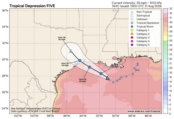
TROPICS: Invest 97L is now Tropical Depression Five, centered about 230 miles southeast of Port Arthur, Texas. It is moving to the west/northwest at 5 mph, and sustained winds are 35 mph. TD5 is forecast to become Tropical Storm Edouard soon, but it will short lived as the system moves into Southeast Texas tomorrow morning.
Elsewhere, the remnants of Tropical Storm Dolly are not expected to develop, and the rest of the Atlantic basin is quiet.
ON THIS DATE IN 1886: A magnitude 7.3 earthquake shook Charleston, South Carolina around 9:50p ET. This earthquake is the most damaging quake to occur in the southeast United States. This earthquake caused 60 deaths and between 5 to 6 million dollars in damage to over 2,000 buildings.
Look for the next video briefing here by 6:00 a.m. tomorrow…



