


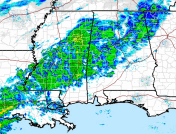
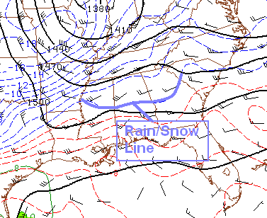
Mainly light snow showers are occurring over parts of Alabama this morning, but so far the precipitation has been very light, and road problems have not occurred in the BHM area so far (that I know of). However, you can see on the above radar that the precipitation gets heavier and more solid in NW Alabama and northern MS, ahead of the Arctic Cold front near the MS River. The low-level flow chart below shows the front (heavy blue curve) and you can see the wind converging on the front. This helps to strengthen the front and the atmosphere’s response is to produce lift and precipitation ahead of the front. That is what is occurring now in northern MS. That is the main deal, and snowfall will increase in central Alabama over the next couple of hours, with accumulations possible by noon.
It is currently 37 degrees in BHM, but it is cold enough to snow in the lower-levels of the atmosphere. The freezing line at 850 mb (about 4,000 feet) is a good indication of the rain/snow line, and it is currently from Aliceville to Clanton to Roanoke.
Also, the atmosphere is still dry at low-levels, as shown by the 6 am balloon data from Calera.
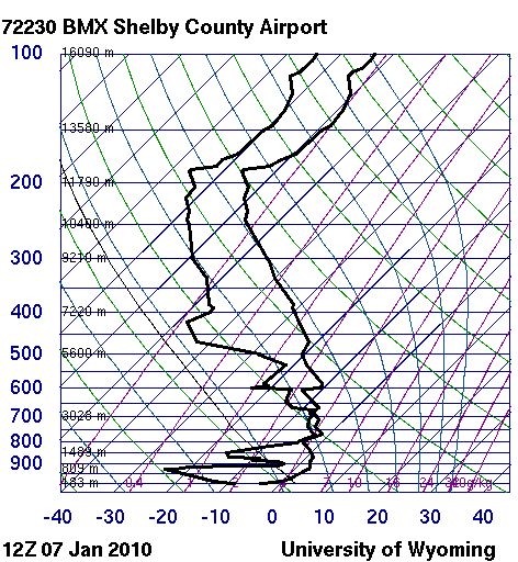
That means some of the snow will evaporate/sublimate on the way down, moistening and cooling the atmosphere (evaporation uses heat), lessening our snow amounts a little bit from what they could be. However, enough snow will fall to moisten the atmosphere up, and we still expect around 1″ in the BHM area this afternoon. Accumulating snow could also occur as far north as Cullman or even Huntsville, and as far south as Grove Hill, Brewton, and Troy before it’s over. The air is also dry at the surface, and despite the temp in BHM in the mid 30s at the surface, the evaporation and melting of snow will bring the temperature down to the wet-bulb temperature, and that is 28 in BHM right now, and below freezing all the way to extreme south Alabama.
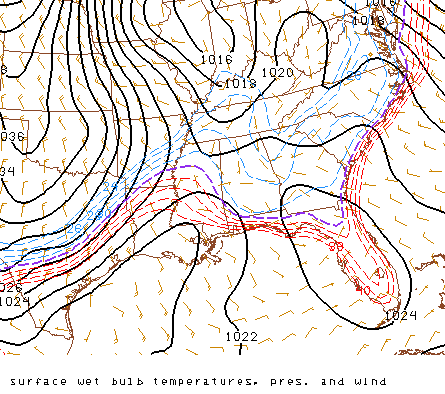
So once the snow gets to falling, temperatures will fall to freezing quickly, and snow accumulation, including on roads and bridges, is likely. Businesses should consider letting employees go home by noon in the BHM area.
The bitterly cold air is still a major concern. So far in 2010, 106 out of 145 hours have been below freezing at BHM. And, other than maybe 2 or 3 hours this morning before the precipitation, at least the next 78 hours, through Sunday morning, will likely be below freezing. Friday and Saturday will be extremely cold, with lows 10 to 15 and highs only in the 20s, with wind chills near zero. Please make sure to check on the elderly and make sure they have adequate, safe heat (space heaters are a fire hazard if used improperly, and kerosene heaters that are old or working improperly can cause carbon monoxide poisoning). If someone you know does not have safe heat, invite them over for a couple of days if possible. Also, please bring the pets in if at all possible, even if you have to put them in a bathroom or something, they won’t mind too much. At this point, many pipes have already frozen, but if you haven’t had any to freeze yet and have any that are vulnerable, do something about them immediately. Also, protect your home from cold air leaking in around poorly-fitting doors and windows using towels or blankets.



