


ZCZC
TTAA00 KUAH 020515
SNOW ANALYSIS 456
UAH WEATHER ANALYSIS DESK
245 AM CST MON FEB 2 2009
sorry for being silly. I’ve been sick this weekend, my wife is working overtime due to year-end accounting, so I’ve had plenty of time to blog and play with the weather.
The cold front is now along a line from near Nashville to Oxford, Mississippi, and the 850 mb 0 C line (usual rain-snow line) extends from Bowling Green to near Memphis. Any surface low development near the Gulf Coast has been very weak, with only a very weak circulation south of Galveston, and pressures barely falling.
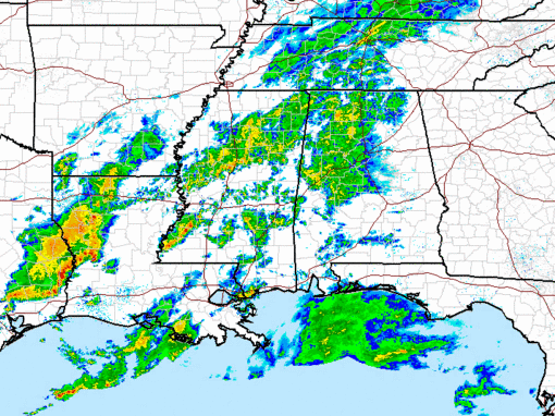
A fair amount of precipitation has formed along the front, with a few thunderstorms from SW Mississippi into Louisiana and east Texas. Light rain has also been increasing over Mississippi and Alabama, associated with weak upper-level impulses and warm air coming in just above the surface ahead of the front.
There is cold air aloft in this environment, and as cold air moves in from the north, and precipitation brings some cold down with it, the rain could change to light snow briefly, but with warm ground temperatures, no big deal. Here is a profile of temperature and wet bulb from UAH Microwave profiling radiometer at 1109 pm:
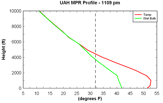
Freezing at 4500 ft., wet-bulb freezing at 3,900 feet. But, rather cold above that, so I wouldn’t count out a light dusting in extreme north and northeast Alabama, but the main area for snow accumulation will probably be near Nashville. In BHM, we may see a few snow flurries as the rain ends around lunchtime, but that’s about all. Just too much warm air to push out of the way, and warm ground temperatures besides. Even with rain falling, temperatures in NW Alabama are still in the upper 40s.
Sorry everyone who wanted snow.



