


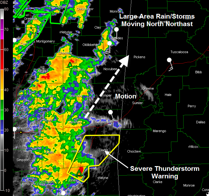
A large mass of rain and thunderstorms over the eastern part of Central Mississippi is growing in intensity and pushing northeastward at this hour.
A severe thunderstorm warning is in effect for areas between Laurel and Meridian. This cell is moving northeast at 35 mph and will reach Sumter and Greene Counties around 1 p.m. and into Pickens and Tuscaloosa Counties by 2 then into Fayette County by 3 p.m. if it holds together.
The rest of the area of rain and storms will reach areas from Marion County down to Sumter County around 1 p.m.
This complex is moving into an area of greater helicity, or spin in the atmosphere, and intensification is likely. Expect damaging winds with the stronger storms, torrential rainfall amounts of 1-2 inches per hour and some hail. There could even be a few tornadoes with embedded supercells.
More storms will form over Southwest Alabama this afternoon and move northeast, affecting areas a little further east, say from Marengo County up through Perry, Bibb, Shelby and Jefferson Counties at late afternoon. Again, heavy rain will be the main threat, but there will invariably be a few storms that produce severe thunderstorm or even tornado warnings.
Then as we go int the evening hours, it appears that the greater threat for intense rainfall will set up as the front edges closer and more deep moisture rushes north out of the Gulf. I think we will see a strong band of rain and storms move out of Mississippi around 5-6 p.m. and move east, eventually merging with the other band and producing some impressive rains over areas from say Selma and Montgomery northeastward to Talladega and Anniston.
Rainfall amounts tonight over East Alabama will easily reach 3 inches and could be even higher. Birmingham might miss out on t he heaviest rain with 1-2 inches still likely.
Back to the west, the cold front is now near Monroe in NE Louisiana, extending down to Lake Charles, pushing slowly east. Further north, it is already into northwestern Mississippi.
This is a situation that is still evolving and will have to be watched carefully through tomorrow morning for the possibility of flooding rains and other modes of severe weather, including tornadoes.



